Atlas of Canada Link: Muriel Lake
Latitude/Longitude:
Degrees, Minutes, Seconds: 49° 7' 37" N 125° 37' 10" W
Decimal Degrees: 49.127° N 125.619° W
UTM Coordinates: 10U 308902 5444878
Topographic Map Sheet Number: 092F04
Trip Date: September 10, 2011
 |
| Muriel Lake |
Getting to Muriel Lake takes two days. Not because it actually takes two days to drive there from Nanaimo, but because we were not heading to Muriel Lake at all -- we were heading to the recreational forestry camp site on Kennedy Lake, hoping to camp there and then paddle down the river to the Kennedy River Bog.
There are a half dozen shirtless and tattooed young men lazing about or wandering about a semi-permanent looking camp at the Kennedy Lake Rec site when we drive up. We changed our plans for where were will sleep the night.
The next morning we are back, but now the put-in by the Kennedy River bridge is blocked by a car with the hatch up and doors open. We walk down to have a look. A sleepy-sounding couple calls hello from a tent under the bridge, "Did you want to launch your boat? We can move our car," the fellow asks. The back of the car is strewn with underwear, food wrappers, and a tipped over foam cooler. "It's OK," I call back, "I think we are going somewhere else."
 |
| The Put-in at the Kennedy River Bridge from my scouting trip in 2008 |
I thought of the conservative American scholar James Q. Wilson's line, "“Arresting a single drunk or a single vagrant who has harmed no identifiable person seems unjust, and in a sense it is. But failing to do anything about a score of drunks or a hundred vagrants may destroy an entire community.”
There is a certain romance in a lone tramp rambling his way through the outskirts of town, or along a remote wilderness, using his wiles and wits to live free and unencumbered. There is also an icy prickle over the skin when you fall under the gaze of 12 shiftless eyes in decidedly shifty circumstances.
My dad used to say, "In the wilderness the most dangerous animals are usually human," and I have heeded this truism whenever my gut gives me pause.
We head to Muriel with some sense of disappointment and apprehension.
When I visited Muriel lake in 2008 the drive was reasonably pleasant and the put-in looked like this:

I am surprised to see how much the road beyond the Kennedy River Bridge has deteriorated in 3 years. Large rocks now protrude from the hard packed road bed and in places the Pacific Ninebark, Thimble Berry and Salmon Berry, and various other bushes, crowd close at the edges. There is a sense that the road could disappear into the forest from lack of use. One spot in the road has recently been filled with soil, the efforts most likely of whomever frequents the two cabins located on the lake. The road down to the lake is definitely best attempted with 4 wheel drive, but the concern is really getting up afterwards as there are some large exposed rock where rain has washed the gravel away.
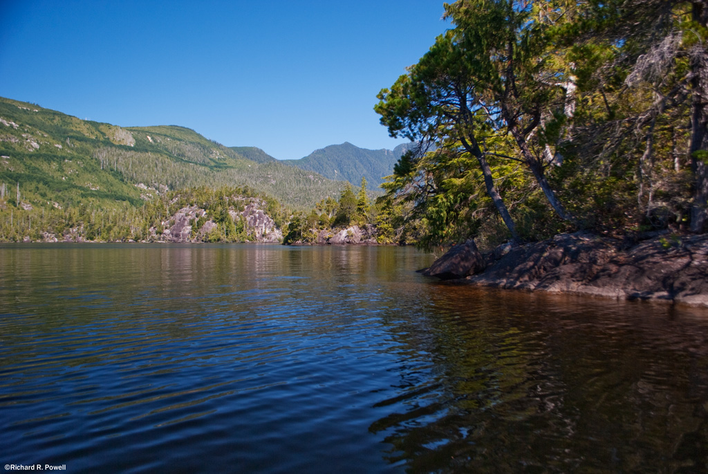
 |
| View from the Put in -- 2011 |
We put our canoes in the water and paddle towards the south eastern corner of the lake, between the two islands visible from the put-in and into a bay filled with water shield.

Paul points out several twisted logs resting on rocks and along the shoreline, their curves and patterns exposed and white under the sun.

These two features, weathered wood and exposed rock, are prevalent themes for the lake. The multiple rocky peninsulas are pleasing combinations of stone and contorted pines. The trees show character in the face of what must be hard winters of torrential downpours and heavy snow.

The heat from the sun is intense so we hug the shady shore, enjoying the rugged beauty of each meter of shoreline.

About 1/4 of the way down the lake we pass a steeply sloped cluster of small rocky islands with one pine doing apparently well amid what seems like very sparse soil conditions. I can't help thinking of my favorite Lone Tree Island on Goose Lake.

We glide over shallow areas where we can see long stretches of rock slanting gradually into the depths, or ending at dark precipices.

On the Northern shore dark green bands of growth show the roads and gullies and I'm thankful that for the moment there are no new clearcuts to distract from the pleasing patchwork of new growth and older forest.

After Paddling for about an hour we get out to stretch our legs on a wide stony shelf a foot below the surface of the water. The cool of the water and the shade from the tall trees give us a chance to contemplate the beauty of the place. We watch schools of small fish moving in and out of the shadows and hear what sounds like a frog plop into the water somewhere down the shore.

When we climb back in our canoes we continue down the lake moving in and out of bays and stopping from time to time to admire large cedar trees. Several handsome specimens of Yellow Cedar stand out amid the more numerous Red Cedar.

Nearing the western end of the lake we disturb a pair of osprey who fly from their nest and seem to lure us away, calling and flying and landing in trees and flying again. We follow them for a ways enjoying their uncommon beauty before turning north and then east to head back into the wind along the northern shore.

The largest island on the lake has some impressive cliffs, but from this side we have trouble seeing where the passage is between it and the northern shore. We paddle hard into the wind and then finally find it, slipping through to find a small archipelago of islands behind it with a houseboat/cabin moored in the protected waters between them.

It strikes me as a perfect spot to tie up, but we don't go ashore, not knowing if this is private property or not. Paul notices Christmas lights on the outside and we can imagine spending a cool evening around the pot bellied stove inside with water lapping at the weathered wood outside.

Then it is back into the teeth of a steady wind, powering our way back to the put-in. We get out, boil water for hot dogs and tea, and while away the afternoon eating, putting away our gear, and enjoying a most pleasant spot.
 |
| Back at the Put-in |


Another lovely area you have to share.
ReplyDeleteHey Richard...when we were at Nahmint Lake we thought about the Kennedy rec site but never noticed Muriel lake...thanks for pointing it out with nice pics as usual...looks like a great little destination
ReplyDeleteLovely photos.
ReplyDeleteBeautiful yet again. I usually go with my gut feeling as well when it comes to leaving my car somewhere. Any doubt is usually for good reason.
ReplyDeleteHola desde España.
ReplyDeleteQué sensación de libertad!!!
Me encantan vuestros paisajes.
Un saludo.
"Hello from Spain.
ReplyDeleteWhat a feeling of freedom!
I love your landscapes.
A greeting."
Thanks Santi! Great to hear from you. Glad the images communicate in any language. :)
Richard
Muriel lake is amzing
ReplyDeleteHi Richard, I am not sure if you will see this, as you created this site along time ago. I am thinking of going to Muriel lake this 2018 summer with my family for some back country camping. What can you tell me of this lake? Did you see any beach or smooth areas (you mention cliffs alot)? Did the lake appear to be well used (abused) by people? Other than that cabin, was there any sign of others? (I like being alone with my family). Did you ever learn if any area around the lake was private property? Any formation you can offer would be very much appreciated. I have searched and can't find much about Muriel lake. Thank you Ross
ReplyDeleteAs a local of the area, I"v been to murial lake many times.A great spot to get away from it all.No private property, the cabin shown was built by the boy scouts many years ago.
ReplyDeleteAccessed by boat only.Many good camping areas aruond the lake.As for the Kennedy rec area, we locals were getting fed up with the way this area was being abused by certain individuals. The area and beaches have been cleaned up.Access is by boat or a short walk.Motor vehicles no longer have access to the beach.Pack it in pack it out applys.Hopefully parks dept will extend the claquot provincial park to cover this area in the future.One more note about the murial lake area.This is a remote area, bear, cougar, wolf, frequent the surroundings. Cell phone coverage is not existent.Keep your dog within eyesight and small children too.Enjoy and respect.
Hi Ross and John, thanks for the comments, sorry for my delay in responding. I a still planning to add more content to this blog, but you know how it goes, lots of demands on time and all that. Ross, I think John has answered some of your questions. I do not recall seeing a lot of good campsites around the lake, but there were definitely two nice places. The shoreline is mostly rocky, which adds much of the charm. A very unique type of landscape in the area in general. But not the best for tenting.
ReplyDeleteJust went in my Westfalia last weekend and it was splendor. The road is risky even in a Vanagon as I did some vehicle damage but it’s still clean. Never slept so peaceful and the mist on the water was breath taking. Would really like to know more about the history of this amazing gem.
ReplyDeleteYes, there does appear to have been a fair bit of life lived on the lake in past years, but I have not been back since this last trip 9 years ago now. Glad to hear the road is still passable, it is an amazing place, would love it to be part of the park as well, so few places like it on the island for paddling.
DeleteHi Richard. Was up that way today on an exploratory hike with the sidekick, found your exact spot. It's a beaut!! Just got back and did a google search for the lake and found your blog.
ReplyDeleteCool, this is such good news. I think of this lake often and hope to return when I have an appropriate vehicle for the task. Thanks for letting me know!
Delete