Atlas of Canada Link: Moran Swamp
Latitude and Longitude: 49o 22' 0" N - 125o 1' 0" W
Trip Date: June 7th, 2008
Constantine Samuel Rafinesque-Schmaltz was an odd fellow. He could not stop naming things in Latin. Born in 1783, by the age of twelve he knew botanical Latin and started a collection of plants (a herbarium) which grew into thousands of specimens until it was lost, along with his collections of shells (60,000 of them) when the ship carrying both, and 50 boxes of his books, sank off the coast of Connecticut in 1815. It is hard to imagine what a loss of this magnitude would do to an collector of his caliber but apparently undeterred by this disaster Sam began collecting again and by 1818 (two years later) he had collected and named more than 250 brand new species of plants and animals. His unquenchable desire to find and name things in the natural world is perhaps unparalleled by any other human. We have Sam to thank for naming both the mule dear(Odocoileus hemionus) and the white footed mouse (Peromyscus leucopus), two of my personal favourites.
 In Medical Flora, a Manual of the Medical Botany of the United States of North America published in 1828 Sam wrote that the underside of the water shield leaf is "...covered with a coat of pale jelly, sometimes purplish, first described by Schreber (Johann Christian Daniel von Schreber)" He went on to explain that, " ...the leaves afford one of the few instance of pure homogeneous vegetable jelly, being spontaneously produced, and covering the whole under surface of the leaves and the stem. Deer and cattle are very fond of eating these leaves; (the animals) even swim in the water in search of them. They are mucilaginous, astringent, demulcent, tonic and nutritious. The fresh leaves may be used like lichen in pulmonary complaints and dysentery. When dry the gelatinous matter almost disappears yet they impart mucilage to water...unnoticed as yet by all medical writers but well known to the Indians."
A scanned copy of the book is available online (http://www.botanicus.org/title/b12058269) and from it one gets the undeniable impression of a man manic for meticulous observation and curious about the healing properties of plants.
 I thought about old Sam while puffing my way up through the forest from Moran Swam with my canoe on my shoulder. I wondered what it must have been like to be the first person to put a name to a new plant, to categorize it and research its medicinal properties. Much of Rafinesque's information of the medicinal properties of the plants was gleaned from first nations experience with the plants and as I read them, I wondered what process first nation's people went through to test each plant. It is ancient knowledge, I suspect, passed on from nameless healers in the distant past.
As it turns out the tender jelly-caked floating leaves of Water Shield that are so sought after by deer and cows are also prized by Japanese culinary mavens. The young curled leaf tips, replete with the thick transparent mucilage, are eaten as a salad with vinegar, sake and soy sauce. They are also used to thicken some soups. In Japan, transparent bottles full of the delicacy line the shelves of better markets. Similar in nutritional make up to other greens like spinach, their unique texture has kept me from harvesting them for my own table. Maybe I need the recipe for the vinegar, sake, and soy sauce combination. Lots of sake I suspect.

I am, at the end of a long day paddling, often humbled and awed by the myriad bounty in the woods, and especially on the margins of any waterway. Salmon berries are always a favourite and I was surprised one year to discover that the large skunk cabbage leaf carefully pressed from the year before had turned into a remarkably resilient parchment on which I could write notes. But the real wonder was the smell. Unlike the flower, the skunk cabbage leaf, when dried, becomes faintly fragrant and it is not at all an unpleasant fragrance. I plan, at some distant date, perhaps when I retire, to take dried skunk cabbage leaves, blend and screen them and see what kind of paper they will make.
 Moran Swamp contains wonders beyond water shield and skunk cabbage, however. It contains the beautiful Eriophorum Chamissonis or Chamisso's Cotton-Grass. I had never noticed this wonderful reed in seed before. I had driven all day, visited different lakes in search of something special, felt frustrated because I had run into snow on the way to Oshinow Lake, and had finally settled for the floating honey dew gardens of Lois Lake, before packing up to head home near 8:00 pm. The summer sun was descending and I was wondering if I could find some place to explore and photograph during the golden hour just before sunset. I had passed the turn off to Moran Swam earlier in the day and my heart had fallen because a crew of loggers was working the ridge beside the swamp harvesting every tree and filling the air with the smell of sawdust and diesel. It is private land, however, and I respect the crew's dominion so I had driven past.
 Now however, on the way back, I saw no sign of activity, and decided to try an old road I knew of that ran below where the crew had been working, hoping that it might still lead to the edge of the swamp. The old road turned out to be badly overgrown and Alder branches squealed and rasped along the side of my Tracker as I made my way along it. I kept looking through the forest on my left for any sign of a path or trail down to the swamp.
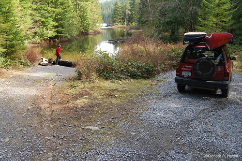
The Road suddenly climbed sharply and merged with a secondary road which turned me directly into the active cut. Large road building machinery sat motionless like slumbering dinosaurs and I drove past several of these muddy toothed giants until I reached a sign that forbade me to travel further. I got out and looked down the road and could just see in the distance the area that used to give access to the swamp. It was now buried by a massive pile of logs. I turned around and drove back along the recently widened spur looking through the trees towards the swamp. Gaps in the branches gave occasional glimpses of open water with sunlight slanting through rugged shore pines on the far shore. After backtracking one more time, I finally settled on a route that began as a steep bank down into a dark forest and then pushed out through dense bushes onto a soggy and bushy shoreline.
 With my canoe slung on my shoulder, paddles and camera in the other hand, and wearing my pfd, I made my way with some effort to the water's edge. I wore knee high paddling boots, which sunk deeply into the reedy meridian of the swamp and when the mud was finally up to the tops of the boots, I set the canoe down and climbed in, pushing my way through the remaining 6 or 8 more feet of soggy reed zone before breaking out onto the open water of the swamp, startling a passing beaver, who slapped her tail wildly and dove under the canoe. She surfaced on the other side a few minutes later to watch me intently before slapping again and then surfaced again on the other side of my boat. She continued to swim near by, occasionally diving with the slap of her tail until I had paddled out into the middle of the open water. I was hot from struggling through the bushes with the canoe on my shoulder and I welcomed a gentle breeze that riffled the water of the swamp as I paddled along. I made my way toward the island which forms the centre of the swamp, and smiled with delight at the sunlight illuminating the sedges and rushes that bordered the island.
 Sedges blowing in the wind glinted pleasingly in late sunlight and I thought of a woman's clean hair. The sound it made in the breeze reminded me of the rustle of skirts, and I had to quell the urge to anthropomorphize the swamp as a living presence birthing graceful water spirits. The beauty, however, was stimulating - the brilliant greens of the sedges in the setting sun, the skeletal trunks of dead trees next to dark green moss-hung living companions, the densely crowded hummocks rising here and there from the water crowned with bobbing white flower heads. It seemed like a planted garden, a carefully tended space that someone had worked at diligently for years until the Sweet Gale formed cloud-like pillows above the darkening water.
 I paddled around the island, watching a bald eagle chased by smaller birds, listening to the evening call of sparrows, the distant gawk of a raven, and finally, just as the sun is winking out behind the western ridge, a loon, somewhere on the other side of the marsh. Then, rounding a corner, I saw the Cotton-Grass. Like characters from Dr. Seuss the tufted heads rocked on the shoulders of their tall graceful stems and the sunlight yellowed the trees behind them giving the scene a dreamlike feel. I idled along the shoreline my eyes skipping from tawny tuft to tawny tuft. I realized that few people would see what I was seeing, that quiet, nameless garden rising to fame in the obscurity of my little mind. I considered that no one knew where I was, that quite possibly no one else had seen this estate of enchantment. Certainly not as I was seeing it then, light draining from the sky, greens resolving into darkness beneath the hemlock and fir.
 So as I strapped the canoe onto the Tracker, thinking of Samuel Rafinesque and his passion for naming, I tried to think of my own label for this place. profundus tabernus silentium (beautiful hut of silence) or perhaps, locus recolligo una profundus (place where little combinations flock into beauty). I thought of Sam, gone so many years, and felt a kinship with him, my own odd delight in finding words for a place of wonder, bordered so close by the buzz of cutting chains and rumbling reapers, my herbarium tucked away as pixels on a thin magic wafer inside my camera.
For more photos of Moran Swamp, in higher resolutions, visit the "pictures only" page that accompanies this trip report at: http://www.stillinthestream.com/files/MoranSwamp/index.html
©Richard R. Powell


 While my son was on the water in the canoe I made my way along the shore casting from the logs and releasing the trout I caught. When it was time to head back I went into the forest thinking it would be shorter than battling the bushes at the lake edge. I immediately surprised a Ruffed Grouse who I had heard drumming earlier. As is the nature of these curious animals, this male did not take flight but simply walked around behind a tree. I walked around the same tree and he walked around another, the erect feathers on the top of his head arching forward and back. When I followed him around his second tree he fanned out his large tail and gave me a shock of beauty I hadn’t had for awhile. “Ok,” I said to him aloud, “If you are going to play the I’m-too-gorgeous-to-eat card, I guess I will have to leave you alone,” and I ventured past, while he sidled casually behind another tree like a gentleman exhibiting a ballroom courtesy.


 First paddle: We took the canoe out first as a tandem and I was immediately impressed with the tracking, stability, and movement through the water. There was very little bow wake until we really pushed it, and the progress along the marsh area we explored was quiet. It was the sort of situation in which you appreciate the boat’s smooth long glide. The tracking has to be the most significant performance feature compared with my other canoes. It felt similar to the tandem Kayak I have paddled in often, going steady and straight with minimal effort required to keep it on track. I was able to take a number of photographs while my son paddled in the bow. He made some corrections and kept the boat on course. The seats were still comfortable after two hours on the water.


 In the bay near the creek a wooden structure stands on a point, bones of a summer camp. Buoys float without moving in the lake. I imagine that in the summer boats, power boats even, dot this shore, oil spilling across the pristine surface. I listen for voices, laughter, splashing children, but it is quiet as velvet, only the small whisper of the creek running out across gravel.
 The sound of the hull contacting with the gravel rouses me and I clamber out to stretch my legs. I spend some time examining stones along the shore. The gravel is uniform in size but sharp edged. This is a young place, the stones have not been smoothed overly, they are recently cracked apart, but the uniformity is pleasing.
 I paddle around the point and towards the second inflow. There is another point, then a sandy bay, then a cluster of shrubs with red branches. As I paddle closer I see that the branches are a variety of shades from orange to pink to red. These bushes are worth the whole trip. I rest my paddle and stare at them, the canoe gliding silently, the sun angling towards the horizon.


