Sunday, 17 October 2010

Second Nanaimo Lake

Trip Date: October 17, 2010

Off road vehicles, 2 of them customized 4Runners, with chopped beds, external cages, and large tires, in a line as a local explains to them that the gate has just been closed. Disappointment and anger on the young men's faces. I wonder, "where will they go now?"

We are not headed for points further up the valley -- we are just going to the boat ramp, though the image does give me a twinge of chagrin. All this land owned by a forest company and the public barred from using it much or most of the time. An old deal which has rubbed people wrong year after year. A give away to big business in exchange for a railway that is only lightly used these days.

The boat ramp has a number of vehicles parked around it. Guys out on the water fishing. We put in with the sound of retreating 4x4s and paddle out and away, heading down to look at the outflow.


The autumn colors warm the landscape but we can see our breath in the shade.


As we approach the bridge we see the smooth surface tilting into rapids so we turn around.


We head back towards the main lake.


The sun is warm and provides a sense of comfort. Two ultralight planes fly low overhead, heading up the broad valley slowly. The day has the feel of a Sunday, lazy and relaxed.


In the distance we see another canoe. People are out enjoying the air, water, and sunshine.


The bushes along the shore are various shades of burgundy and amethyst. The Ninebark is yellow and orange.


We paddle slowly and take it all in. Further up the lake we coast beside a large wall of stone with large and small trees growing out of cracks. It is too dark in the shade of the hillside to take pictures. I have to just soak it in. I keep looking and looking and can't get enough. At one point a bright yellow clump of Ninebark protrudes out from between a vertical  fissure in the rock face. Paul and I both comment repeatedly on the beauty. We talk about people we know that have a hard time seeing it or valuing it. I think about learning to appreciate abstract art in my first year at University. Removing preconceptions and expectations and just looking at what is before you. Letting the art evoke a feeling.

We round the corner and eat our lunch on a log strewn shore with the sound of water or wind, we never can decide which, coming from the dense forest behind us. Two fly fishermen go by in a skiff. We chat with them and they tell us that the Elk were not on the gravel bar today.


In order to make sure we are out before the gate is closed, we cut our trip short and head back. On another day we will explore the sand bar and maybe see those Elk. Two blue herons fly over us low and close enough to see the feathers moving in their wings.

We stop on the way home and wander into the woods looking for Mushrooms.


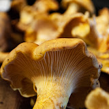
There are Chanterelles -- slightly waterlogged and perhaps indicating the peak of the season, and a small patch of Hedgehogs, firm and smelling sweet. These are Hydnum umbilicatum. I have not gathered them before.


The teeth or spines are clearly visible under the magnifying glass when I get home.


There is also a Western Amethyst Laccaria, which I am not as sure about both in the field and when I get home. But when I look in the books I gain confidence. I will do a spore print tonight.  Edibility of this mushroom seem in question but it has a lovely fresh smell.

I also saw but did not gather what I think was a either a Zellers or Admirable Bolete. Being not on wood, but on the side of the road, I lean towards the Zellers.

I have a satisfied sense of gratitude as I put my mushrooms in the fridge at the end of the night. It has been a good day.

Monday, 11 October 2010

Stella and Lower Stella Lakes

Trip Date: October 3rd, 2010

James and I had visited the area of Stella, Lower Stella, Pye and McCreight Lakes last year but the day had been windy and the lakes were uninviting. This day the Weather Network predicted low winds so we decided to try again. A sign at the entrance to Rock Bay Road informed us that the road would be closed the next day for logging in the Stella Lake area. We congratulated ourselves on visiting the lakes just in time.

We stopped briefly at McCreight, but the long narrow valley seems always to channel wind down the lake. Today was no exception. We drove on, enjoying the country between McCreight and Stella, a lowland of meandering streams and deep water marshes.

Lower Stella looked calm and inviting, but we checked our watches and decided we could probably get a paddle in on both Stella and Lower Stella; so headed on to Stella. At the put in a lone angler was navigating his aluminum skiff with an electric motor towards the beach where he was camped. The wind was running out of the South East and the sheltered bay was inviting enough. We set off along the North Eastern shore protected from the main wind by the protruding headland at the transition to the main lake.


Once we passed the headland we headed Southwest towards the island that stands off from the point between the two large bays on the Northern end of the lake. Rocky on the southern shore and lush and dense with foliage on the Northern side, the island does not appear to receive many visitors. No obvious campsite was evident but there was a fire ring on the high rocks on the western side. I got out and crashed through the bushes for awhile trying to find a route to high ground before giving up and returning to my canoe.


We headed back to the put-in, enjoying the Northern shore and outflow before taking out and heading to Lower Stella.


Lower Stella is the haunt of generations of anglers. A grandfather on our last visit was introducing his grandchildren to the special place. A fisherman's poem is carefully nailed to a tree near the put-in and because there is no easy way to launch a boat of any significant size, I suspect only canoes, light skiffs, and pontoon boats make it onto the lake.


The light was fading but we headed out, circumnavigating the lake counter clockwise. The inflow is picturesque, but the most endearing aspect of the lake is the long southern shore with it's grassy fringe and striking contrast of light alder trunks against the dark forest behind.


With the chill of evening penetrating our shirts we finished out paddle and headed to have a look at the Pye Lake Rec Site, which we found and wandered through in the last light before dark. Pye was also calm and we wished we had a little more day left to explore it. We decided to return again on another day.


Fore more photos of Lower Stella visit the photo gallery here.

Thursday, 7 October 2010

McNair Lake

Trip Date: October 3, 2010

As I gingerly ease the Tracker in and out of the large holes that crater the road leading away from McNair Lake, the springs in the seat creak and we sway this way and that. My passenger (contented and glowing from sucking in great drafts of beauty) leans over conspiratorially and says  "You won't blog about this place, right?"

I've heard this appeal before. The concern seems to be that if I show people what a special place it is they will all flock to it and trample the beauty into mud and gravel and then throw beer cans and old tarps in the water. We have seen this in too many other places already.
Lunch At McNair
The trouble is, that if the yahoos don't be-spoil it the forest companies probably will. The trees around McNair are getting big enough to harvest. Before long the saws will start to whine and the hillsides will lose their beautiful blanket of undulating fir to be replaced by a patchwork of logging cuts. Beauty is not nearly as valuable as logs and fiber.

I'm not against logging. I'm not a tree spiker or tree hugger. But I have to confess I feel pretty sad to think that this area will soon look like a half plucked chicken.

The Sayward forest should, in my humble opinion, be protected because of it's beauty. But my opinion isn't likely to have much effect on changing the fate of this place. Still, I do what I can. And part of what I can do is post some photos and at least let posterity see what a beautiful place this was before the loggers had their way with it.


Because of course once the saws get busy it will be a hundred years or more before it will look like this again. I'll be long gone by then. I wonder if my photos will remain? Probably not.

So what is this post about then? Perhaps just one human mind contemplating how everything changes and celebrating the beauty while it is still here.

For more photos of McNair Lake, click here.

Sunday, 19 September 2010

Chanterelle Season!

I was not overly motivated to get out on the water this weekend, but I did take two long walks between rain showers and saw lots of mushrooms, including hundreds of Fircone cap -- that funky little mushroom that grows out of fir cones littered on the forest floor.

Of the edible kind I saw a few Rosy Gomphidius, some puffballs, and happily some Pacific Golden Chanterelles. Of the non edible variety I was fortunate to see what I believe was Clustered collybia along with some very large Rosy Russulas and some very badly mangled Wooly Chanterelles.

From Mushroom Hunt -- September 18, 2010
To view a video of the habitat I found these in, and some more photos, see the album here:

Mushroom Hunt -- September 18, 2010

Friday, 17 September 2010

Farewell Lake

I visited Farewell Lake with Tom in the late and lazy days of August. It was a perfect day on an enchanting "off the beaten path" lake in the Sayward Forest.

We ate our lunch here at the place the outflow becomes a creek over rocks too shallow to admit canoes at this time of year.

For more photos visit my Jalbum Album of Farewell Lake.

Tuesday, 7 September 2010

Pixie Lake

The road from the main to the put-in is overgrown and has two large deep puddles. We waded in to test the depth before putting the Tracker in 4 wheel drive and fording through. At the lake edge a swarm of wasps arrived to examine the hot vehicle.

I stood back nervously but James was brave.

After a few minutes the wasps lost interest and we put out onto a strange and eerie world. the shoreline bristled with dead trees, watershield decomposed under the sun, dark deep water slid under our hulls.

We did not see any pixies, but at one point James commented that it was the sort of place you thought you might look into the water and see ghostly white faces looking back with dead eyes.

Memorable would be a word to describe the experience.

Here is a photo album of the paddle: http://www.homestead.com/rrpowell/files/PixieLake

Friday, 6 August 2010

Lone Tree Island


I visited Lone Tree Island (on Goose Lake) three times in as many years. The first time was with my 15 year old son, Graham, in 2008. He idled away into a nearby bay while I tied my canoe to a weathered log and got out to have a look around.


The fissured black rock under foot was warm in the afternoon sun and wavelets lapped at it's edge. The traction of the rock felt satisfying, it's sureness underfoot, a relief when so much around was either slippery or muddy.

I walked carefully across the island's moss, mostly dry and whispering underfoot, then looked for a long time at the lone pine tree, rooted in a low depression of the rock on the northern edge of the island. Probably the only place where anything like soil could gather.


The tree's roots snaked out across the rock in ribbons -- wiry tendrils with thin living veins on the underside. Scared, gnarled, old.


Walking up to the tree I found that the limbs contained twisted bunches of branches resembling some internal mass of arteries exposed during an operation. Severed branches ended in sticky pitch. The human compulsion to cut wood.


I moved slowly, noticing sprigs of hard hack, the conical cluster of fuzzy pink flowers that bees love. The moss compacted underfoot. Looking down I saw red ground plants, and as I ducked under one of the big branches, a layer of pine needles crackled under my Keens like they would in a fire.


On one side of the tree  limbs had been hacked off, hurried amputations as if from a machete or Sandvik bush axe -- the wounds scabbed over with hard cloudy pitch.

I turned and looked back at my canoe; the burgundy hull bobbed slightly against the dark gray volcanic rock, the sun bleached log spanning across to a smaller island and bright green sedges glowed in dappled sunlight.


I sat on the rock by the canoe for a few minutes, feeling the place, connecting to it. I looked back at the tree. Hoped it would survive for a long time.

A few weeks later I brought James to the spot. The nearby campsite was occupied, so I didn't spend much time on Lone Tree Island. But paddling past I couldn't help wanting to get out. I noticed how the tree, from the side, had the look of a bonsai, the triangle of branches like something out of one of  Peter Chan's books.

The water around the island was flashing, the amber silt like a blanket tucked in underneath.


We returned to our campsite and the next morning, for some reason, I was drawn to a place I could look out on Lone Tree Island. What was it's allure? What made it so pleasing?


Just recently, after not visiting Goose Lake for a year, I returned with friends, and one evening I made my way over to the island again.


I pulled Paul's Wenonah Rendezvous (Classic tuff weave lay-up) up on the North side of the island this time, resting the hull on a spot of gravel and sedges.


I walked a few paces to a slight rise and looked again at the tenacious pine. The setting sun was still lighting the hardy tree in a warm glow, while I stood in the cool of the shade from the trees on the western shore.  The weathered old log was gone, no doubt it floated free in one of the winter storms. Nothing stays the same, everything changes. But the rock, the general shape of the island seemed comfortingly constant and the tree - it's survival questionable, added tension to the scene.


I looked across to the northern shore of the lake at the small island at the end of the peninsula there. I thought, for some reason of the film adaptation of Great Expectation with Ethan Hawke, where young Fin is out walking in the shallows searching for fish. There are, after all, many places in the world like this, stretches of shallow water with little islands. This place, just happens to be near me, and in the grand scheme of things, it is not particularly spectacular or special. But of course, it is. And that is the mystery.


Places like this have something of the desert, something of the desert island. This island is basically a rock, and in a setting such as off the nearby west coast of Vancouver Island, it would be lost, subsummed into the common place by all the other similar rocky outcrops -- just one of many. But here, surrounded on all sides by forested shores, it takes on a quality something like a refuge, a breathing space, a contrast to dense forest.


Here, in this context, the solidity of the rock is comforting, the tenacity of the lone tree inspiring, the nakedness of the rock sensual and appealing. It is a testimony to the combination of things, to the rule of a special place being greater than the sum of it's parts. It is artistic, or perhaps more accurately, aesthetic. Easy on the eyes, pleasing to the feet, a sense satisfying locus.


Part of the appeal is that this hump of rock, evoking somehow the sense of a whales back breaking the surface, is so solid while just inches beyond it's shore the silty bottom deepens into a death trap of sucking glue. There is a prickly awareness being here, like walking past sleeping alligators, like sauntering just out of reach of a caged tiger. The danger is there, but the chance of mishap is slim as long as you keep your wits about you.


And then there is the view, in every direction, of green wilderness. There are logging cuts here and there. For the moment they seem tactfully hidden from view, but there are no houses yet, no docks and breakwaters, no developments or marinas. But of course there could be, might someday be. While Lone Tree Island is just a part of a larger landscape, it draws some of it's appeal from being situated within a wider vista. A Wild vista. And I guess I hope it will stay that way.


So much wilderness is being purchased, controlled,  and managed, that I feel sad contemplating the ultimate fate of places like this. Will Lone Tree Island be free sold to the highest bidder? Or can this patch of Crown Land remain with the people, protected from development. I hope it can.

Goose Lake --
hearing the wind coming
tree by tree

Sunday, 1 August 2010

Goose Lake

Vancouver Island Backroad Mapbook 4th edition - Map 40 B5
Atlas of Canada Link:Mohun Lake (North)
Latitude and Longitude: 50° 8' 24" N 125° 29' 48" W
Decimal Degrees: 50.14° N 125.497° W
UTM Coordinates: 10U 321589 5557209
Topographic Map Sheet Number: 092K03

Trip Date: July 27 to 30th, 2010

Goose Lake Map

There is a lot of traffic on Goose Lake these days. As the first leg of the Sayward Forest Canoe Route there is a steady stream of canoes and kayaks heading north towards the portage to Twin Lake. The Northern bay has some decent trout in it too, so that brings anglers in skiffs, powerboats, and Zodiacs. The rotting pilings from the old bridges at the narrows keep the water skiers out, but not the jet skis. And it is only going to see more traffic as the population of Vancouver Island increases.

So why am I broadcasting the location to the world wide web? Because I would like to see this fragile and beautiful environment protected so people can keep on enjoying it for a long time to come. As Michel Gauthier points out in his excellent guide to the Canoe Circuit, "By using the resource, we plant a stake in the ground, a flag that represents our will, our wants, and our desire. The more of us who paddle the circuit, the bigger the flag, the more visible it is to them [the policy makers]. We become a constituency. Our use of the resource forces government officials to take us into consideration when they make decisions affecting the area we have claimed."

The beauty of this place may not be grandiose, but it is impressive in it's subtlety.

The first subtle beauty of the place is it's shallowness.


Notice the paddle swirls in the bottom mud behind Paul in this shot? there is something magical about zipping along over the honey colored silt only a few feet below. Schools of stickleback dart away and even the dusky speckled leaches are beautiful to watch as they nose alone sunken logs in search of hiding places.


The golden color comes from the lake bottom which is a soft blanket of decaying algae, pine pollen, and organic matter. In places you can thrust a paddle 4 feet into it without striking anything solid. All the water from Goose and Mohun lakes (and their tributaries) appears to drain out the small creek that leads to Morton Lake. For most of the year the flow is gentle, so the silt has a chance to settle out.

What this means is that it is a great place for aquatic plants to grow, particularly Yellow Pond Lilly, Watershield, Floating Leaved Pondweed, and Water Lobelia.

Floating-Leaved Pondweed
 Here Paul examines a bed of Verticillate Watermilfoil mixed with Widgeon grass:


The Milfoil, a native species, forms slightly disturbing underwater brain structures:


This is sedgebending territory, with a fair number of reeds and rushes for good measure.


The second subtle beauty of this place is the rock. There are a number of rocky islands and points, as well as rocky escarpments and rock gardens.

Rock Garden with Water Lobilia

I think the main rock here is a basalt. According to this map the Goose Lake area sits squarely atop Karmutsen Volcanic Rocks and Quatsino Limestone. One prospector states that "As we head north from Campbell River towards Sayward, the area is almost entirely underlain by Karmutsen basalts near the top of the section." On Goose Lake these volcanic bones emerge in places to add a solid contrast to the softer textures of water and woods.


All of the good campsites have this stone underfoot, but it is particularily obvious at G5, 6, and 7 and the un-numbered site in the Western Bay:

We appreciated the Shade to Eat Our Lunch In

There is a swirl of stone on this point that looks like it may have been a popped bubble of lava:


One of my favorite places on Goose Lake is Lone Tree Island, which I will devote another post to entirely. This island is a large stone projecting from the water with a beautiful pine with undulating roots that stretch out across the rock:


Lone Tree Island contains the third subtle beauty: Pines. Shore Pines to be exact. Also called Bonsai Pines and Bog Pines. The scientific name is Pinus contorta and it is well adapted to growing on rocks and beside the water.

Sunrise over Pine at Campsite G6
Campsite G6 is on the south side of a picturesque island on which are growing numerous beautiful specimens, not least of which are the ones growing in the campsite itself.


The dense "cloud-like" bunches of branches on these specimens make great shade and the trees are strategically located to provide shelter from the sun most of the day.

That tree on the right has a good example of how the pine trunch and branches twist and turn as they grow. Here is a close up:


The contorted pines continue to grace the landscape when they fall down and loose their bark, revealing their beautiful twisted interiors.


 This combination of shallow water, volcanic rock, and trees with deep character make this a place to experience wabi sabi in abundance. It is an experience worth savoring.

I hope that you will visit Goose Lake and tread lightly when you do. But please do visit, and tell your friends, and tell your political representatives that this unique and beautiful treasure needs to be protected, enhanced, and saved for your children and their children.

The campsites need better toilets and some signs to let people know how fragile the environment is. Tables would prevent the cutting of trees and small wooden docks in places would prevent the deterioration of the shoreline habitat.

A big thanks must be given to the Comox Valley Paddlers who have installed the cedar toilet boxes in some campsites.

Lets hope that Ministry of Tourism, Culture and the Arts which now managers the area will receive funding to maintain and protect this valuable natural resource. This is a premier recreational location in western Canada and deserves careful management.