On my travels around Vancouver Island I see first hand the ugly impact of logging on our own rainforests. I'm not against responsible logging, but we have to leave larger areas of old growth to preserve the genetic diversity and aesthetic value that used to dominate this island.
I wonder if people realize how much beauty has already been lost. It is staggering. Almost all the lakes I visit have ugly logged sections around them. It takes 300 years to grow a mature forest. We are not going to see them again in our lifetime, so we should think seriously about how much we cut down. Aesthetic value needs to be recognized along with economic value.
If you walk in an old growth forest, or paddle beside one, it changes you, and if you plant and protect more forests, they can save the world. Where are BC's environmental laws? Almost non-existant. If our government won't respond to this urgent need, we need to look elsewhere. Here is a way you can help:
Thursday, 23 July 2009

Thursday, 2 July 2009
Anutz Lake
Vancouver Island Backroad Mapbook - Map 36 D1
Atlas of Canada Link: Anutz Lake
Latitude and Longitude: 50o 17' 59" N - 126o 55' 0" W
Trip Date: June 21st, 2009
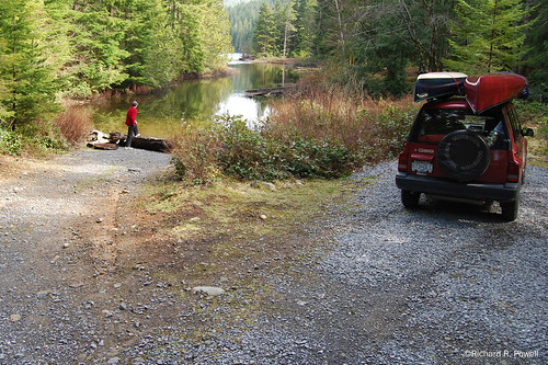
I arrive late Sunday afternoon, wind blowing straight at the beach, sun bleaching the view. An assortment of robins work the Thimble Berry and Pacific Ninebark bushes. No one is at the site but there are deep ATV ruts along the beach and in the middle of the field, a circle where an ATV went around and around. It feels a bit like a ghost town. I decide to camp close behind the row of bushes that separate the beach from the campsites.
 I cook dinner, read for awhile, then explore the beach to the west and discover a place where water has created a flow of limestone out from a small opening in the rock — a white tongue of stone. I climb up onto a 14 foot high rock outcropping and watch the waves, listen to the wind in the forest.
 Red Paintbrush shocks from side to side in the wind. I scramble down onto some lower rocks worn by water, the waves making hollow gurgling sounds below my feet somewhere under the rock.
 Then around the corner I find a sculpted stone with a hole right through the middle.
 I explore the forest; find a trail that leads back to the campsites through a nice mature second growth woodland, stopping briefly to admire a patch of Pacific Lilly of the Valley.
 Still no-one at the campsite when I break out of the forest into the open field. The 10,000 clusters of Pacific Ninebark blossoms bob at the margin of the meadow, Yellow Salmon Berriers, gone pink where eaten by some animal shine in the growing dark.
 I photograph a Nootka Rose and examine the berries forming on a twinberry bush, the woundlike bracts somehow disquieting my mind when I look at them up close. I crane my neck to look at mares tails in the sky, listen to a bird call I don’t recognize, the sound like a child’s toy whistle, a single rising note, as if questioning, tentatively, the coming night.
 I accept that the wind is not letting up tonight, return to my camp, try to read but the noseeums find me. I put on bug spray. A male grouse thumps his call, almost too low to hear, while the robins give up their evening melodies to a scattered ramble of chirps. Sky goes pink, then a few puffy clouds are left, orange around the edges.
 Then the silence after climbing into my sleeping bag inside my tent. I fall asleep sometime after 10:30, wake after midnight chilled and pull on my sweater, the tips of the trees out the tent window are still against the dark grey sky. The night never gets completely dark in June. At 3:00 I wake and listen to the grouse call, It is the only sound in the darkness. At 6:00 I scramble out of the tent and walk to the beach. The sun is just lighting up the peaks of the Karmutzen Range (Nimpkish Lake was named Karutzen lake for awhile) and a mist is rising from the lake.
 I hurry back, put my down vest over my wool sweater, then the PFD, pulling on my paddling boots and gortex pants. I take down my canoe, load up some food and other supplies and am on the water in a few minutes, paddling towards the western area where two creeks empty into a marshy estuary.
 Fish that have been lolling at the surface break away from me in the early light and disappear amid the Lilly pads.
 The current moves in swirls between the floating pads and I can see that a beaver has been at work attempting to bridge the entire estuary with a low dam. I find an opening and push through.
 There turn out to be three inflows; all but one shrouded with sedges and rushes and the middle one has a curious feature. A log is wedged between the banks, forming a natural dam so that the water on the other side of the log is several feet higher than where I float in my canoe. There is a deep hollow sound of water like the sound of a bathtub filling as the water flows from beneath the log into a collection of smaller debri and I wonder how long this tiny cascade will exist. I listen to it for awhile before exploring some of the floating gardens growing on the ends of a half submerged logs. Yellow Monkey Flowers bob over the water along side Fire weed and gracefully curving sedges, each blade pointed with a shinning drop of dew.
 I turn and paddle down the western shore towards the river that connects Anutz and Nimpkish Lake. Stickleback cruse in the shallow water along the river banks, a king fisher skims the surface going past fast, his flight arch taking him sharply up to light on a tree branch, scold me, then head off down river. The current picks up over the shallow bars of gravel, then deep clear pools green towards the stony bottom. Widgeon grass sways like the skirts of a Hawaiian dancer as I go around a corner and under an overhanging tree.
 I pass two side channels which I know are oxbows from examining the area on Google Earth. Then the final long stretch and the narrowing just before Nimpkish Lake, where the old pilings are. I drift out into the lake on the current, paddle to shore and stroll the beach, eating a granola bar and drinking some water.
The sun crests over the mountain but only flashes briefly before disappearing behind clouds; there is a tiny riffle far out on Nimpkish Lake. I take off my down vest and drink some more water.
 The paddle back upriver is slower, working only slightly harder against the current. Robins, always lots of robins, call in the salal and I turn in at the first oxbow to listen to them. There is a family of mergansers, the young fledglings lanky and shy, and as I drift towards them the hen takes flight, the ducklings disappear under the brown surface like skin divers. I turn around and head back, but some of the ducklings have surfaced behind me, lurking under the edges of Lilly Pads, and I startle them back underwater. Out on the river again I turn upstream and the hen angles in behind me to find her offspring.
 I notice a beaver lodge I hadn’t seen on the way downstream. New branches are piled on one side, leaves wilting, the bone-white cuts concave and drying in the still air. As I turn the corner and make my way up the straight run to Anutz Lake a bald eagle circles above the tall pine trees that grow along the eastern shore. I suspect these trees are old; beyond the reach of loggers in the marshlands. As I stop to look at them the waves from my boat reach the shore and rebound back, so that I am rocked gently in their soundless echo.
 Half way across Anutz the sun breaks out, I take a picture of the vista, with sunlight on different altitudes of land. In the middle of the lake I can not hear anything.
 The green of the new sedges along the shore glows in the sun, a warmth that goes deep into the brain, gentle x-rays etching solitude in memory.

For More photos of this trip, see the gallery here: http://www.stillinthestream.com/files/AnutzLake/index.html
Atlas of Canada Link: Anutz Lake
Latitude and Longitude: 50o 17' 59" N - 126o 55' 0" W
Trip Date: June 21st, 2009
I arrive late Sunday afternoon, wind blowing straight at the beach, sun bleaching the view. An assortment of robins work the Thimble Berry and Pacific Ninebark bushes. No one is at the site but there are deep ATV ruts along the beach and in the middle of the field, a circle where an ATV went around and around. It feels a bit like a ghost town.
 I decide to camp close behind the row of bushes that separate the beach from the campsites.
 I cook dinner, read for awhile, then explore the beach to the west and discover a place where water has created a flow of limestone out from a small opening in the rock — a white tongue of stone. I climb up onto a 14 foot high rock outcropping and watch the waves, listen to the wind in the forest.
 Red Paintbrush shocks from side to side in the wind. I scramble down onto some lower rocks worn by water, the waves making hollow gurgling sounds below my feet somewhere under the rock.
 Then around the corner I find a sculpted stone with a hole right through the middle.
 I explore the forest; find a trail that leads back to the campsites through a nice mature second growth woodland, stopping briefly to admire a patch of Pacific Lilly of the Valley.
 Still no-one at the campsite when I break out of the forest into the open field. The 10,000 clusters of Pacific Ninebark blossoms bob at the margin of the meadow, Yellow Salmon Berriers, gone pink where eaten by some animal shine in the growing dark.
 I photograph a Nootka Rose and examine the berries forming on a twinberry bush, the woundlike bracts somehow disquieting my mind when I look at them up close. I crane my neck to look at mares tails in the sky, listen to a bird call I don’t recognize, the sound like a child’s toy whistle, a single rising note, as if questioning, tentatively, the coming night.
 I accept that the wind is not letting up tonight, return to my camp, try to read but the noseeums find me. I put on bug spray. A male grouse thumps his call, almost too low to hear, while the robins give up their evening melodies to a scattered ramble of chirps. Sky goes pink, then a few puffy clouds are left, orange around the edges.
 Then the silence after climbing into my sleeping bag inside my tent. I fall asleep sometime after 10:30, wake after midnight chilled and pull on my sweater, the tips of the trees out the tent window are still against the dark grey sky. The night never gets completely dark in June. At 3:00 I wake and listen to the grouse call, It is the only sound in the darkness. At 6:00 I scramble out of the tent and walk to the beach. The sun is just lighting up the peaks of the Karmutzen Range (Nimpkish Lake was named Karutzen lake for awhile) and a mist is rising from the lake.
 I hurry back, put my down vest over my wool sweater, then the PFD, pulling on my paddling boots and gortex pants. I take down my canoe, load up some food and other supplies and am on the water in a few minutes, paddling towards the western area where two creeks empty into a marshy estuary.
 Fish that have been lolling at the surface break away from me in the early light and disappear amid the Lilly pads.
 The current moves in swirls between the floating pads and I can see that a beaver has been at work attempting to bridge the entire estuary with a low dam. I find an opening and push through.
 There turn out to be three inflows; all but one shrouded with sedges and rushes and the middle one has a curious feature. A log is wedged between the banks, forming a natural dam so that the water on the other side of the log is several feet higher than where I float in my canoe. There is a deep hollow sound of water like the sound of a bathtub filling as the water flows from beneath the log into a collection of smaller debri and I wonder how long this tiny cascade will exist. I listen to it for awhile before exploring some of the floating gardens growing on the ends of a half submerged logs. Yellow Monkey Flowers bob over the water along side Fire weed and gracefully curving sedges, each blade pointed with a shinning drop of dew.
 I turn and paddle down the western shore towards the river that connects Anutz and Nimpkish Lake. Stickleback cruse in the shallow water along the river banks, a king fisher skims the surface going past fast, his flight arch taking him sharply up to light on a tree branch, scold me, then head off down river. The current picks up over the shallow bars of gravel, then deep clear pools green towards the stony bottom. Widgeon grass sways like the skirts of a Hawaiian dancer as I go around a corner and under an overhanging tree.
 I pass two side channels which I know are oxbows from examining the area on Google Earth. Then the final long stretch and the narrowing just before Nimpkish Lake, where the old pilings are. I drift out into the lake on the current, paddle to shore and stroll the beach, eating a granola bar and drinking some water.
The sun crests over the mountain but only flashes briefly before disappearing behind clouds; there is a tiny riffle far out on Nimpkish Lake. I take off my down vest and drink some more water.
 The paddle back upriver is slower, working only slightly harder against the current. Robins, always lots of robins, call in the salal and I turn in at the first oxbow to listen to them. There is a family of mergansers, the young fledglings lanky and shy, and as I drift towards them the hen takes flight, the ducklings disappear under the brown surface like skin divers. I turn around and head back, but some of the ducklings have surfaced behind me, lurking under the edges of Lilly Pads, and I startle them back underwater. Out on the river again I turn upstream and the hen angles in behind me to find her offspring.
 I notice a beaver lodge I hadn’t seen on the way downstream. New branches are piled on one side, leaves wilting, the bone-white cuts concave and drying in the still air. As I turn the corner and make my way up the straight run to Anutz Lake a bald eagle circles above the tall pine trees that grow along the eastern shore. I suspect these trees are old; beyond the reach of loggers in the marshlands. As I stop to look at them the waves from my boat reach the shore and rebound back, so that I am rocked gently in their soundless echo.
 Half way across Anutz the sun breaks out, I take a picture of the vista, with sunlight on different altitudes of land. In the middle of the lake I can not hear anything.
 The green of the new sedges along the shore glows in the sun, a warmth that goes deep into the brain, gentle x-rays etching solitude in memory.
For More photos of this trip, see the gallery here: http://www.stillinthestream.com/files/AnutzLake/index.html
Saturday, 16 May 2009
Hawthorn Lake
Vancouver Island Backroad Mapbook - Map 15 B6
Atlas of Canada Link: Hawthorn Lake
Latitude and Longitude: 49o 3' 0" N - 124o 46' 0" W
Trip Date: April 23rd, 2009
I spent the day exploring lakes along Bamfield Road. Unable to find a trail to Black Lake, I decided to head for Lizard Pond, but encountered active logging just past Hawthorn Lake. So I returned to Hawthorn and put in with fairly low expectations. I followed a pair of Barrow's Golden Eyes for several meters and was surprised when they did not fly away. As my canoe drifted sideways while I stopped paddling to raise the camera for a shot, the size of my profile suddenly registered as a threat and they took off. I later encountered more Golden Eye on the far side of the lake, and they too were slow to spook.
These are perhaps my favorite local freshwater duck -- much more impressive than the Common Goldeneye. This little sea duck is less dramatic than the Wood Duck, but more aproachable, and the startling contrast of the male's purple head with the yellow eye ring can be quite entrancing.
 Shortly after that I observed numerous newts sunning at the surface of the lake, only tilting downward as I approached. A flash of orange belly as they turned to dive confirmed for me that they were Taricha granulosa, the Rough-Skinned Newt.
The Rough Skinned Newt is the only newt I have observed so far on Vancouver Island. The other common resident Aquatic Salamanders, the Northwestern Salamander, and the Long-Toed Salamander, have so far eluded me, but the Rough Skinned Newt seems to be everywhere. I have seen them in roadside ponds near Courtenay, and in McNair Lake near Campbell River. On McNair, I was fortunate to see a group of them gathered in a ball, a behavior I first read about in Corkran and Thoms' Amphibians of Oregaon, Washington, and British Columbia, the book I recommend to budding phibs, or amphibian watchers like myself.
Monday, 9 March 2009
Still Water Fishing Information on Helpful DVD

The DVD is available at Walmart, Gone Fishin' in Port Alberni, and Ed's Fix It Shop in Lake Cowichan, and the Vancouver Island Regional Library. Not perhaps the most informative production I have ever seen, it is never the less a good introduction to fly fishing with chironomid and mayfly patterns. The camera work is clear, with only a few unhelpful off target frames, and the conversational style natural and informative.
One thing I was struck by was the quantity and quality of the gear used. From the power boat to the multiple reals and lines, fishing is not presented as a poor man's sport. Oh well, I was able to add a few things to my wish list.
Wednesday, 18 February 2009
New Forum for Paddlers to Share Info About Lakes on Vancouver Island
I just started a group on "The Canoeist" and would like to invite all Vancouver Island paddlers who are interested to visit and post trip reports, photos, videos, etc. and to join in discussing favorite lakes to paddle, directions to the best put ins, camping spots, and all that helpful stuff that can make all the difference when paddling new water.
I will be moderating the group in a very easy going fashion, so feel free to participate and make others feel at home.
Here is the link: http://www.thecanoeist.com/group/lakesonvancouverisland
I will be moderating the group in a very easy going fashion, so feel free to participate and make others feel at home.
Here is the link: http://www.thecanoeist.com/group/lakesonvancouverisland
Saturday, 29 November 2008
Moran Swamp
Vancouver Island Backroad Mapbook - Map 24 D6
Atlas of Canada Link: Moran Swamp
Latitude and Longitude: 49o 22' 0" N - 125o 1' 0" W
Trip Date: June 7th, 2008
Constantine Samuel Rafinesque-Schmaltz was an odd fellow. He could not stop naming things in Latin. Born in 1783, by the age of twelve he knew botanical Latin and started a collection of plants (a herbarium) which grew into thousands of specimens until it was lost, along with his collections of shells (60,000 of them) when the ship carrying both, and 50 boxes of his books, sank off the coast of Connecticut in 1815. It is hard to imagine what a loss of this magnitude would do to an collector of his caliber but apparently undeterred by this disaster Sam began collecting again and by 1818 (two years later) he had collected and named more than 250 brand new species of plants and animals. His unquenchable desire to find and name things in the natural world is perhaps unparalleled by any other human. We have Sam to thank for naming both the mule dear(Odocoileus hemionus) and the white footed mouse (Peromyscus leucopus), two of my personal favourites.
 In Medical Flora, a Manual of the Medical Botany of the United States of North America published in 1828 Sam wrote that the underside of the water shield leaf is "...covered with a coat of pale jelly, sometimes purplish, first described by Schreber (Johann Christian Daniel von Schreber)" He went on to explain that, " ...the leaves afford one of the few instance of pure homogeneous vegetable jelly, being spontaneously produced, and covering the whole under surface of the leaves and the stem. Deer and cattle are very fond of eating these leaves; (the animals) even swim in the water in search of them. They are mucilaginous, astringent, demulcent, tonic and nutritious. The fresh leaves may be used like lichen in pulmonary complaints and dysentery. When dry the gelatinous matter almost disappears yet they impart mucilage to water...unnoticed as yet by all medical writers but well known to the Indians."
A scanned copy of the book is available online (http://www.botanicus.org/title/b12058269) and from it one gets the undeniable impression of a man manic for meticulous observation and curious about the healing properties of plants.
 I thought about old Sam while puffing my way up through the forest from Moran Swam with my canoe on my shoulder. I wondered what it must have been like to be the first person to put a name to a new plant, to categorize it and research its medicinal properties. Much of Rafinesque's information of the medicinal properties of the plants was gleaned from first nations experience with the plants and as I read them, I wondered what process first nation's people went through to test each plant. It is ancient knowledge, I suspect, passed on from nameless healers in the distant past.
As it turns out the tender jelly-caked floating leaves of Water Shield that are so sought after by deer and cows are also prized by Japanese culinary mavens. The young curled leaf tips, replete with the thick transparent mucilage, are eaten as a salad with vinegar, sake and soy sauce. They are also used to thicken some soups. In Japan, transparent bottles full of the delicacy line the shelves of better markets. Similar in nutritional make up to other greens like spinach, their unique texture has kept me from harvesting them for my own table. Maybe I need the recipe for the vinegar, sake, and soy sauce combination. Lots of sake I suspect.

As I reached the road -- the shoulder muscles under my canoe spasming -- I pondered how many edible plants surround the average paddler, sliding past bull rushes, and bog lilies. Of course edible does not equate to palatable. I had read that indigenous residents of our coast picked and ate vast numbers of Salal berries and so plucked some ripe ones at the end of a long warm August and popped them in my mouth. Pithy and sour, I could imaging enjoying only their laxative properties, the taste disappearing in the overwhelming texture of fibre and roughage. Unlike the less plentiful but equally well utilized huckleberry, I do not seek out Salal berries to supplement my mid day meals.
I am, at the end of a long day paddling, often humbled and awed by the myriad bounty in the woods, and especially on the margins of any waterway. Salmon berries are always a favourite and I was surprised one year to discover that the large skunk cabbage leaf carefully pressed from the year before had turned into a remarkably resilient parchment on which I could write notes. But the real wonder was the smell. Unlike the flower, the skunk cabbage leaf, when dried, becomes faintly fragrant and it is not at all an unpleasant fragrance. I plan, at some distant date, perhaps when I retire, to take dried skunk cabbage leaves, blend and screen them and see what kind of paper they will make.
 Moran Swamp contains wonders beyond water shield and skunk cabbage, however. It contains the beautiful Eriophorum Chamissonis or Chamisso's Cotton-Grass. I had never noticed this wonderful reed in seed before. I had driven all day, visited different lakes in search of something special, felt frustrated because I had run into snow on the way to Oshinow Lake, and had finally settled for the floating honey dew gardens of Lois Lake, before packing up to head home near 8:00 pm. The summer sun was descending and I was wondering if I could find some place to explore and photograph during the golden hour just before sunset. I had passed the turn off to Moran Swam earlier in the day and my heart had fallen because a crew of loggers was working the ridge beside the swamp harvesting every tree and filling the air with the smell of sawdust and diesel. It is private land, however, and I respect the crew's dominion so I had driven past.
 Now however, on the way back, I saw no sign of activity, and decided to try an old road I knew of that ran below where the crew had been working, hoping that it might still lead to the edge of the swamp. The old road turned out to be badly overgrown and Alder branches squealed and rasped along the side of my Tracker as I made my way along it. I kept looking through the forest on my left for any sign of a path or trail down to the swamp.
The Road suddenly climbed sharply and merged with a secondary road which turned me directly into the active cut. Large road building machinery sat motionless like slumbering dinosaurs and I drove past several of these muddy toothed giants until I reached a sign that forbade me to travel further. I got out and looked down the road and could just see in the distance the area that used to give access to the swamp. It was now buried by a massive pile of logs. I turned around and drove back along the recently widened spur looking through the trees towards the swamp. Gaps in the branches gave occasional glimpses of open water with sunlight slanting through rugged shore pines on the far shore. After backtracking one more time, I finally settled on a route that began as a steep bank down into a dark forest and then pushed out through dense bushes onto a soggy and bushy shoreline.
 With my canoe slung on my shoulder, paddles and camera in the other hand, and wearing my pfd, I made my way with some effort to the water's edge. I wore knee high paddling boots, which sunk deeply into the reedy meridian of the swamp and when the mud was finally up to the tops of the boots, I set the canoe down and climbed in, pushing my way through the remaining 6 or 8 more feet of soggy reed zone before breaking out onto the open water of the swamp, startling a passing beaver, who slapped her tail wildly and dove under the canoe. She surfaced on the other side a few minutes later to watch me intently before slapping again and then surfaced again on the other side of my boat. She continued to swim near by, occasionally diving with the slap of her tail until I had paddled out into the middle of the open water. I was hot from struggling through the bushes with the canoe on my shoulder and I welcomed a gentle breeze that riffled the water of the swamp as I paddled along. I made my way toward the island which forms the centre of the swamp, and smiled with delight at the sunlight illuminating the sedges and rushes that bordered the island.
 Sedges blowing in the wind glinted pleasingly in late sunlight and I thought of a woman's clean hair. The sound it made in the breeze reminded me of the rustle of skirts, and I had to quell the urge to anthropomorphize the swamp as a living presence birthing graceful water spirits. The beauty, however, was stimulating - the brilliant greens of the sedges in the setting sun, the skeletal trunks of dead trees next to dark green moss-hung living companions, the densely crowded hummocks rising here and there from the water crowned with bobbing white flower heads. It seemed like a planted garden, a carefully tended space that someone had worked at diligently for years until the Sweet Gale formed cloud-like pillows above the darkening water.
 I paddled around the island, watching a bald eagle chased by smaller birds, listening to the evening call of sparrows, the distant gawk of a raven, and finally, just as the sun is winking out behind the western ridge, a loon, somewhere on the other side of the marsh. Then, rounding a corner, I saw the Cotton-Grass. Like characters from Dr. Seuss the tufted heads rocked on the shoulders of their tall graceful stems and the sunlight yellowed the trees behind them giving the scene a dreamlike feel. I idled along the shoreline my eyes skipping from tawny tuft to tawny tuft. I realized that few people would see what I was seeing, that quiet, nameless garden rising to fame in the obscurity of my little mind. I considered that no one knew where I was, that quite possibly no one else had seen this estate of enchantment. Certainly not as I was seeing it then, light draining from the sky, greens resolving into darkness beneath the hemlock and fir.
 So as I strapped the canoe onto the Tracker, thinking of Samuel Rafinesque and his passion for naming, I tried to think of my own label for this place. profundus tabernus silentium (beautiful hut of silence) or perhaps, locus recolligo una profundus (place where little combinations flock into beauty). I thought of Sam, gone so many years, and felt a kinship with him, my own odd delight in finding words for a place of wonder, bordered so close by the buzz of cutting chains and rumbling reapers, my herbarium tucked away as pixels on a thin magic wafer inside my camera.
For more photos of Moran Swamp, in higher resolutions, visit the "pictures only" page that accompanies this trip report at: http://www.stillinthestream.com/files/MoranSwamp/index.html
©Richard R. Powell
Atlas of Canada Link: Moran Swamp
Latitude and Longitude: 49o 22' 0" N - 125o 1' 0" W
Trip Date: June 7th, 2008
Constantine Samuel Rafinesque-Schmaltz was an odd fellow. He could not stop naming things in Latin. Born in 1783, by the age of twelve he knew botanical Latin and started a collection of plants (a herbarium) which grew into thousands of specimens until it was lost, along with his collections of shells (60,000 of them) when the ship carrying both, and 50 boxes of his books, sank off the coast of Connecticut in 1815. It is hard to imagine what a loss of this magnitude would do to an collector of his caliber but apparently undeterred by this disaster Sam began collecting again and by 1818 (two years later) he had collected and named more than 250 brand new species of plants and animals. His unquenchable desire to find and name things in the natural world is perhaps unparalleled by any other human. We have Sam to thank for naming both the mule dear(Odocoileus hemionus) and the white footed mouse (Peromyscus leucopus), two of my personal favourites.
 In Medical Flora, a Manual of the Medical Botany of the United States of North America published in 1828 Sam wrote that the underside of the water shield leaf is "...covered with a coat of pale jelly, sometimes purplish, first described by Schreber (Johann Christian Daniel von Schreber)" He went on to explain that, " ...the leaves afford one of the few instance of pure homogeneous vegetable jelly, being spontaneously produced, and covering the whole under surface of the leaves and the stem. Deer and cattle are very fond of eating these leaves; (the animals) even swim in the water in search of them. They are mucilaginous, astringent, demulcent, tonic and nutritious. The fresh leaves may be used like lichen in pulmonary complaints and dysentery. When dry the gelatinous matter almost disappears yet they impart mucilage to water...unnoticed as yet by all medical writers but well known to the Indians."
A scanned copy of the book is available online (http://www.botanicus.org/title/b12058269) and from it one gets the undeniable impression of a man manic for meticulous observation and curious about the healing properties of plants.
 I thought about old Sam while puffing my way up through the forest from Moran Swam with my canoe on my shoulder. I wondered what it must have been like to be the first person to put a name to a new plant, to categorize it and research its medicinal properties. Much of Rafinesque's information of the medicinal properties of the plants was gleaned from first nations experience with the plants and as I read them, I wondered what process first nation's people went through to test each plant. It is ancient knowledge, I suspect, passed on from nameless healers in the distant past.
As it turns out the tender jelly-caked floating leaves of Water Shield that are so sought after by deer and cows are also prized by Japanese culinary mavens. The young curled leaf tips, replete with the thick transparent mucilage, are eaten as a salad with vinegar, sake and soy sauce. They are also used to thicken some soups. In Japan, transparent bottles full of the delicacy line the shelves of better markets. Similar in nutritional make up to other greens like spinach, their unique texture has kept me from harvesting them for my own table. Maybe I need the recipe for the vinegar, sake, and soy sauce combination. Lots of sake I suspect.

I am, at the end of a long day paddling, often humbled and awed by the myriad bounty in the woods, and especially on the margins of any waterway. Salmon berries are always a favourite and I was surprised one year to discover that the large skunk cabbage leaf carefully pressed from the year before had turned into a remarkably resilient parchment on which I could write notes. But the real wonder was the smell. Unlike the flower, the skunk cabbage leaf, when dried, becomes faintly fragrant and it is not at all an unpleasant fragrance. I plan, at some distant date, perhaps when I retire, to take dried skunk cabbage leaves, blend and screen them and see what kind of paper they will make.
 Moran Swamp contains wonders beyond water shield and skunk cabbage, however. It contains the beautiful Eriophorum Chamissonis or Chamisso's Cotton-Grass. I had never noticed this wonderful reed in seed before. I had driven all day, visited different lakes in search of something special, felt frustrated because I had run into snow on the way to Oshinow Lake, and had finally settled for the floating honey dew gardens of Lois Lake, before packing up to head home near 8:00 pm. The summer sun was descending and I was wondering if I could find some place to explore and photograph during the golden hour just before sunset. I had passed the turn off to Moran Swam earlier in the day and my heart had fallen because a crew of loggers was working the ridge beside the swamp harvesting every tree and filling the air with the smell of sawdust and diesel. It is private land, however, and I respect the crew's dominion so I had driven past.
 Now however, on the way back, I saw no sign of activity, and decided to try an old road I knew of that ran below where the crew had been working, hoping that it might still lead to the edge of the swamp. The old road turned out to be badly overgrown and Alder branches squealed and rasped along the side of my Tracker as I made my way along it. I kept looking through the forest on my left for any sign of a path or trail down to the swamp.
The Road suddenly climbed sharply and merged with a secondary road which turned me directly into the active cut. Large road building machinery sat motionless like slumbering dinosaurs and I drove past several of these muddy toothed giants until I reached a sign that forbade me to travel further. I got out and looked down the road and could just see in the distance the area that used to give access to the swamp. It was now buried by a massive pile of logs. I turned around and drove back along the recently widened spur looking through the trees towards the swamp. Gaps in the branches gave occasional glimpses of open water with sunlight slanting through rugged shore pines on the far shore. After backtracking one more time, I finally settled on a route that began as a steep bank down into a dark forest and then pushed out through dense bushes onto a soggy and bushy shoreline.
 With my canoe slung on my shoulder, paddles and camera in the other hand, and wearing my pfd, I made my way with some effort to the water's edge. I wore knee high paddling boots, which sunk deeply into the reedy meridian of the swamp and when the mud was finally up to the tops of the boots, I set the canoe down and climbed in, pushing my way through the remaining 6 or 8 more feet of soggy reed zone before breaking out onto the open water of the swamp, startling a passing beaver, who slapped her tail wildly and dove under the canoe. She surfaced on the other side a few minutes later to watch me intently before slapping again and then surfaced again on the other side of my boat. She continued to swim near by, occasionally diving with the slap of her tail until I had paddled out into the middle of the open water. I was hot from struggling through the bushes with the canoe on my shoulder and I welcomed a gentle breeze that riffled the water of the swamp as I paddled along. I made my way toward the island which forms the centre of the swamp, and smiled with delight at the sunlight illuminating the sedges and rushes that bordered the island.
 Sedges blowing in the wind glinted pleasingly in late sunlight and I thought of a woman's clean hair. The sound it made in the breeze reminded me of the rustle of skirts, and I had to quell the urge to anthropomorphize the swamp as a living presence birthing graceful water spirits. The beauty, however, was stimulating - the brilliant greens of the sedges in the setting sun, the skeletal trunks of dead trees next to dark green moss-hung living companions, the densely crowded hummocks rising here and there from the water crowned with bobbing white flower heads. It seemed like a planted garden, a carefully tended space that someone had worked at diligently for years until the Sweet Gale formed cloud-like pillows above the darkening water.
 I paddled around the island, watching a bald eagle chased by smaller birds, listening to the evening call of sparrows, the distant gawk of a raven, and finally, just as the sun is winking out behind the western ridge, a loon, somewhere on the other side of the marsh. Then, rounding a corner, I saw the Cotton-Grass. Like characters from Dr. Seuss the tufted heads rocked on the shoulders of their tall graceful stems and the sunlight yellowed the trees behind them giving the scene a dreamlike feel. I idled along the shoreline my eyes skipping from tawny tuft to tawny tuft. I realized that few people would see what I was seeing, that quiet, nameless garden rising to fame in the obscurity of my little mind. I considered that no one knew where I was, that quite possibly no one else had seen this estate of enchantment. Certainly not as I was seeing it then, light draining from the sky, greens resolving into darkness beneath the hemlock and fir.
 So as I strapped the canoe onto the Tracker, thinking of Samuel Rafinesque and his passion for naming, I tried to think of my own label for this place. profundus tabernus silentium (beautiful hut of silence) or perhaps, locus recolligo una profundus (place where little combinations flock into beauty). I thought of Sam, gone so many years, and felt a kinship with him, my own odd delight in finding words for a place of wonder, bordered so close by the buzz of cutting chains and rumbling reapers, my herbarium tucked away as pixels on a thin magic wafer inside my camera.
For more photos of Moran Swamp, in higher resolutions, visit the "pictures only" page that accompanies this trip report at: http://www.stillinthestream.com/files/MoranSwamp/index.html
©Richard R. Powell
Tuesday, 13 May 2008
Amor Lake
Vancouver Island Mapbook - Map 40 A3
Atlas of Canada Link: Amor Lake
Latitude and Longitude: 50o 10' 0" N - 125o 32' 59" W
Trip Date: May 4th, 2008
The day before our trip it rained. The next morning the sky was grey and wind chilled our hands as we strapped the canoes onto the Tracker. The weather forecast said the sun would come out; there would be some late afternoon wind, but not a drop of rain. The next day would be clear and calm. I read several different reports and said a prayer. Then we headed out.
Just past Courtney the sky lightened and by the time we reached Campbell River the sun was out. We arrived at the lake in the early afternoon, backed our Tracker to the water’s edge and loaded our supplies and gear into the canoes. The put in is a pretty spot where the lake funnels all the water collected from surrounding Mud, Twin, and Surprise Lakes, and several smaller un-named bodies, into the creek that leads to Blackwater Lake, then Farewell Lake, and on down to Amor de Cosmos creek which flows through McCreight Lake before finally exiting into the Johnson Strait.
 Several aluminium skiffs bumped gently against logs with powerful looking outboard motors raised and glinting in the sun. In a campsite on the far side of the creek a Great Dane and another large dog barked menacingly at us till their owners shushed them. The two beasts stood erect watching us with the slight tremors you see in animals trained to stay, but itching to give pursuit.

We pushed the canoes into the channel and began paddling away. A robin sat on a log watching us as we made the small adjustments of gear and foot pegs necessary to get comfortable in a boat with a larger load than usual.

Then we were pushing out, past the confines of the protective cove, past three men in a power boat attempting to negotiate a shallow channel that connects behind one of the numerous small islands on the lake. A jovial and somewhat inebriated bowman informed us that there were no fish in the lake, at least as far as he could tell, while the captain in the stern lifted the prop creating that guttural growl props make when taken from their usual environment. We pushed on around the corner, the wind at our backs, gliding along in the joy that rises as you begin to realize you are leaving it all behind while the pines and firs and cedars luff around you like sails, the wavelets lapping against the hull.

As we paddled through the sheltered water behind the island that marks the transition from the south western arm of the lake, to the main body of the lake we could see that it was blowing north to south down the lake, creating a moderate chop. We paused in the shelter of a promontory and then headed into the wind. By sticking close to shore, we avoided the hard work of paddling directly into a wind and soon were nosing our way into a sheltered bay with a sandy beach. We went ashore and explored a pleasant campsite with a kitchen station created from a tree root mass.
 It was a nice spot, but we were keen to check out some other sites so we headed north again, then spied the island we suspected contained the Sterling Island Rec Site and headed for it.


I have to confess that the site has a magic about it. Like passengers from the fated Minnow, we knew at once that this was the place we would be spending the night. The campsite itself is located on a relatively flat area in the centre of the island surrounded by trees and salal bushes with an impressive fire pit constructed with some skill from large angular stones. An L-shaped bench on one side of the fire pit is constructed of a weathered cedar log and an equally weathered plank. We immediately hauled our canoes to high ground, set up our tent, and strung a tarp between trees on the north side of the site against the brisk north wind. I was worried that we might regret the choice of the Northern most island directly in the teeth of the gale, so to speak, but behind our tarp we were comfortable enough and the wind certainly kept the bugs away.

We found our container of fire wood (I always like to bring my own when I don’t know how much is available on site) and assembled our Portable Buck Saw and found a large pine limb that had fallen, we surmised, in the recent heavy spring snow and proceeded to buck it up. I also found one weather worn piece of cedar on the beach which we set aside for the evening fire.


The morning broke cold and calm. Canada Geese surrounded the island and seemed to be engaged in some sort of territorial dispute that required goosy conversation at full volume.
 After watching the sun rise I started a fire in the Little Bug Stove and soon had water boiling in the Kelly Kettle. My son took charge of the frying pan and the smell and sizzle of sausages filled the camp. Combined with steaming scrambled eggs and store bought cinnamon buns it made a mouth watering meal. As is often the case in the outdoors, the food was tastier by far than the same meal would have been prepared at home.

After breakfast we dismantled camp, loaded the canoes and headed out. I tried fishing and we cruised the lake, now beautifully calm, admiring the rocky shoreline and thick second growth forest, and enjoyed the sensation of gliding over a sunken world.
 We made our way to the Mr. Canoehead Rec Site and found it silent and spacious under a full canopy.

We wandered up the short portage to Surprise Lake, saw fish rising, and headed back to Amor Lake to fetch one of the canoes. We then spent a happy two hours fly fishing, both of us reeling in firm cutthroat trout from the crystal clear water. While my son was on the water in the canoe I made my way along the shore casting from the logs and releasing the trout I caught. When it was time to head back I went into the forest thinking it would be shorter than battling the bushes at the lake edge. I immediately surprised a Ruffed Grouse who I had heard drumming earlier. As is the nature of these curious animals, this male did not take flight but simply walked around behind a tree. I walked around the same tree and he walked around another, the erect feathers on the top of his head arching forward and back. When I followed him around his second tree he fanned out his large tail and gave me a shock of beauty I hadn’t had for awhile. “Ok,” I said to him aloud, “If you are going to play the I’m-too-gorgeous-to-eat card, I guess I will have to leave you alone,” and I ventured past, while he sidled casually behind another tree like a gentleman exhibiting a ballroom courtesy.
Atlas of Canada Link: Amor Lake
Latitude and Longitude: 50o 10' 0" N - 125o 32' 59" W
Trip Date: May 4th, 2008
The day before our trip it rained. The next morning the sky was grey and wind chilled our hands as we strapped the canoes onto the Tracker. The weather forecast said the sun would come out; there would be some late afternoon wind, but not a drop of rain. The next day would be clear and calm. I read several different reports and said a prayer. Then we headed out.
Just past Courtney the sky lightened and by the time we reached Campbell River the sun was out. We arrived at the lake in the early afternoon, backed our Tracker to the water’s edge and loaded our supplies and gear into the canoes. The put in is a pretty spot where the lake funnels all the water collected from surrounding Mud, Twin, and Surprise Lakes, and several smaller un-named bodies, into the creek that leads to Blackwater Lake, then Farewell Lake, and on down to Amor de Cosmos creek which flows through McCreight Lake before finally exiting into the Johnson Strait.
 Several aluminium skiffs bumped gently against logs with powerful looking outboard motors raised and glinting in the sun. In a campsite on the far side of the creek a Great Dane and another large dog barked menacingly at us till their owners shushed them. The two beasts stood erect watching us with the slight tremors you see in animals trained to stay, but itching to give pursuit.
We pushed the canoes into the channel and began paddling away. A robin sat on a log watching us as we made the small adjustments of gear and foot pegs necessary to get comfortable in a boat with a larger load than usual.

Then we were pushing out, past the confines of the protective cove, past three men in a power boat attempting to negotiate a shallow channel that connects behind one of the numerous small islands on the lake. A jovial and somewhat inebriated bowman informed us that there were no fish in the lake, at least as far as he could tell, while the captain in the stern lifted the prop creating that guttural growl props make when taken from their usual environment. We pushed on around the corner, the wind at our backs, gliding along in the joy that rises as you begin to realize you are leaving it all behind while the pines and firs and cedars luff around you like sails, the wavelets lapping against the hull.

As we paddled through the sheltered water behind the island that marks the transition from the south western arm of the lake, to the main body of the lake we could see that it was blowing north to south down the lake, creating a moderate chop. We paused in the shelter of a promontory and then headed into the wind. By sticking close to shore, we avoided the hard work of paddling directly into a wind and soon were nosing our way into a sheltered bay with a sandy beach. We went ashore and explored a pleasant campsite with a kitchen station created from a tree root mass.
 It was a nice spot, but we were keen to check out some other sites so we headed north again, then spied the island we suspected contained the Sterling Island Rec Site and headed for it.
We approached from the North, running with the wind, and navigated easily around the small island to a lovely quiet spot on the South eastern shore. There we beached the canoes and had a look around.

I have to confess that the site has a magic about it. Like passengers from the fated Minnow, we knew at once that this was the place we would be spending the night. The campsite itself is located on a relatively flat area in the centre of the island surrounded by trees and salal bushes with an impressive fire pit constructed with some skill from large angular stones. An L-shaped bench on one side of the fire pit is constructed of a weathered cedar log and an equally weathered plank. We immediately hauled our canoes to high ground, set up our tent, and strung a tarp between trees on the north side of the site against the brisk north wind. I was worried that we might regret the choice of the Northern most island directly in the teeth of the gale, so to speak, but behind our tarp we were comfortable enough and the wind certainly kept the bugs away.

We found our container of fire wood (I always like to bring my own when I don’t know how much is available on site) and assembled our Portable Buck Saw and found a large pine limb that had fallen, we surmised, in the recent heavy spring snow and proceeded to buck it up. I also found one weather worn piece of cedar on the beach which we set aside for the evening fire.
In the interest of keeping the carbon release low I broke out our Little Bug stove and soon had a roaring little fire which quickly mellowed into the sort of flame that begs for hot dogs. It just so happened that we had such culinary delights along and set to the task of roasting them.

Before long the sun was setting and we shook out the coals from the Little Bug stove and mounded the wet pine and weathered cedar so that we could enjoy the crackle (and hiss) of a full blow fire. Nothing, and I say this without hyperbole, creates a more receptive and peaceful mind than the gentle act of fire gazing after a relaxing day of paddling. The silence expanded as the wind died down and the embers dropped into a dry hush, such a soothing experience that language seemed too rude to bring to voice. These shared moments of contemplation are silken raiment’s on a day of rest. We left the dying coals and went to the beach to stare up at the stars. We stood, blinking at the universe before heading back to camp and our bed rolls.

The morning broke cold and calm. Canada Geese surrounded the island and seemed to be engaged in some sort of territorial dispute that required goosy conversation at full volume.
 After watching the sun rise I started a fire in the Little Bug Stove and soon had water boiling in the Kelly Kettle. My son took charge of the frying pan and the smell and sizzle of sausages filled the camp. Combined with steaming scrambled eggs and store bought cinnamon buns it made a mouth watering meal. As is often the case in the outdoors, the food was tastier by far than the same meal would have been prepared at home.
After breakfast we dismantled camp, loaded the canoes and headed out. I tried fishing and we cruised the lake, now beautifully calm, admiring the rocky shoreline and thick second growth forest, and enjoyed the sensation of gliding over a sunken world.
 We made our way to the Mr. Canoehead Rec Site and found it silent and spacious under a full canopy.
We wandered up the short portage to Surprise Lake, saw fish rising, and headed back to Amor Lake to fetch one of the canoes. We then spent a happy two hours fly fishing, both of us reeling in firm cutthroat trout from the crystal clear water.
While my son was on the water in the canoe I made my way along the shore casting from the logs and releasing the trout I caught. When it was time to head back I went into the forest thinking it would be shorter than battling the bushes at the lake edge. I immediately surprised a Ruffed Grouse who I had heard drumming earlier. As is the nature of these curious animals, this male did not take flight but simply walked around behind a tree. I walked around the same tree and he walked around another, the erect feathers on the top of his head arching forward and back. When I followed him around his second tree he fanned out his large tail and gave me a shock of beauty I hadn’t had for awhile. “Ok,” I said to him aloud, “If you are going to play the I’m-too-gorgeous-to-eat card, I guess I will have to leave you alone,” and I ventured past, while he sidled casually behind another tree like a gentleman exhibiting a ballroom courtesy.Back at Amor we pushed off and made our way over more sunken mysteries (lilly pad roots? Waterlogged docks? Is that a train tressel?) and all too soon we were pulling our canoes out of the water surrounded by a new collection of campers. We chatted with some folks who had been coming to Amor Lake for years and wished them luck as they headed onto the water, willow leaf lures flashing from their rods.
 Summation: Amor Lake is a moderately sized lake that epitomizes the paddling pleasure of the Sayward Forest area. Multiple small islands and coves provide that, “I wonder what’s around the next bend” feeling and multiple arms (5) allow for many optional destinations. We only explored the southern reaches of the lake, not even half its area, and I think it is reasonable to say that you could spend three happy days on the lake exploring its various coves and islands. We counted 4 obvious campsites not counting the 8 or more sites located beside the boat launch. The map indicates that there are two more campsites on the eastern arm of the lake and I suspect there are others on the two northerly arms as well. Regarding fishing, there were three small power boats and a row boat at the boat ramp when we arrived and in past visits I have observed numerous power boats. The folks we talked to had trolling gear and Vancouverisland.com lists the following resident species: Cutthroat Trout, Dolly Varden Char, Kokanee Salmon, but Amor Lake is not scheduled to be stocked by the Freshwater Fisheries Society in 2008 and does not appear to have been stocked in recent years. So I would not expect good fishing from such a heavily fished body of water that is not stocked.
 Recommendations: Wind does seem to be a common complaint made by folks who have paddled the lake as part of the Sayward canoe route and I know that nearby Brewster Lake routinely produces whitecaps on summer days from noon to dusk, so if you are interested in paddling Amor consult your weather forcast and pick a calm day or alternatively plan to paddle during the morning or evening hours. Even during the mid-day bluster if you keep near the shore you will have lots of opportunities to duck behind rocks and logs, and into bays and coves for respite from the wind. None of the sites we looked at had outhouses so bring a shovel or trowel and use common sense when burying your business. The Sterling Island Rec Site has a makeshift toilet (an upturned bucket with the bottom cut out) and while this arrangement is functional, I wonder about its long term viability. If you are of the enlightened and forward thinking tribe who pack out even your pooh, well, I salute you. I don’t think the pressure is currently strong enough to warrant this level of diligence at Amor Lake, but once people find what a treasure this area is, it might need to be practiced before long by all of us. For a handy reference to this subject see: Pooping Perfectly in the Woods By Kevin Callan
 For more photos (and larger versions of the ones pictured here) go to: http://rrpowell.homestead.com/files/amorlake/index.html
©Richard R. Powell
Sunday, 20 April 2008
Whymper Lake
Vancouver Island Mapbook - Map 39 G7
Atlas of Canada Link: Whymper Lake
Latitude and Longitude: 50o 2' 59" N - 125o 35' 59" W
Trip Date: April 18, 2008
It’s funny where you end up sometimes. I headed first to Snakehead Lake but found the lake whipped up by a strong wind from the North, so I headed to Camp Lake, but loggers and equipment were everywhere and the crew boss was not happy with me “bombing along” his road, so I left and headed back to the Sayward Forest again. My son and I paddled there the week before and on our way past Whymper Lake I said to him, “that looks nice.” So I went to Whymper.

I think it is fairly safe to say that almost no one goes to Whymper Lake on purpose. Paddlers on the Sayward Forest Canoe Route must pass through the lake, but it would take a determined small water paddler like me to find this little jewel with so many larger gems near by. There is no boat launch ramp, no trail to the lake edge, only the portage trail which is all but unseen from the roadside.
I decided to see if there was a way to enter the creek above the lake so that I could paddle down the bushy corridor leading to the lake. I found an overgrown road leading to a crumbling old bridge but the alders were completely covering the road and I was only able to pull the Tracker off the main road enough to unload. A short bushwhack to the creek edge and I was away.

The lake is essentially a swelling of the creek and I could always feel the tug of the current on the hull, even in the largest flat part of the lake. The wind was gusty, but such a small body of water does not allow any kind of real chop to develop and I found that if I cruised near the shore, the wind hardly bothered me.
I paddled around for about two hours looking at the new bulrush leaves poking out of the mud, watching migrating water fowl pass overhead, and examining a profuse amount of what I later identified as Sweet Gale, or Myrica gale. The waxy catkins of this aromatic wetland shrub appear before the leaves and these catkins were just cracking open in the spring sunshine. The golden hue of them lit the grey boarders of the lake with a gentle glow.
Sweet Gale is reported to be on the badge of the Campbell clan, and having found this shrub in great abundance this close to Campbell River seemed apropos.
According to Mrs. M Grieve, “The leaves (of Sweet Gale) are often dried to perfume linen, etc., their odour being very fragrant, but the taste bitter and astringent. The branches have been used as a substitute for hops in Yorkshire and put into a beer called there 'Gale Beer.' It is extremely good to allay thirst. The catkins, or cones, boiled in water, give a scum beeswax, which is utilized to make candles. The bark is used to tan calfskins; if gathered in autumn, it will dye wool a good yellow colour and is used for this purpose both in Sweden and Wales. The Swedes use it in strong decoction to kill insects, vermin and to cure the itch. The dried berries are put into broth and used as spice. In China, the leaves are infused like tea, and used as a stomachic and cordial.”Gotta love a shrub that can do all that.
I look forward to visiting this area again after the plants leave out. I noticed Caddisfly larvae moving on the muddy bottom and would expect this to be a productive section of stream for the fly angler even though my dry fly arrangement did not produce any takers and I had left my wet fly reel in the vehicle.
If you decide to seek out this lake be aware that the shoreline is composed of fragile bog plants. I recommend doing as I did and enter the lake via the stream where the creek edge is less vulnerable to human impact.
For more photos go to: http://www.flickr.com/photos/stillinthestream/
and click on the 100 Lake Project link.
©Richard R. Powell
Atlas of Canada Link: Whymper Lake
Latitude and Longitude: 50o 2' 59" N - 125o 35' 59" W
Trip Date: April 18, 2008
It’s funny where you end up sometimes. I headed first to Snakehead Lake but found the lake whipped up by a strong wind from the North, so I headed to Camp Lake, but loggers and equipment were everywhere and the crew boss was not happy with me “bombing along” his road, so I left and headed back to the Sayward Forest again. My son and I paddled there the week before and on our way past Whymper Lake I said to him, “that looks nice.” So I went to Whymper.

I think it is fairly safe to say that almost no one goes to Whymper Lake on purpose. Paddlers on the Sayward Forest Canoe Route must pass through the lake, but it would take a determined small water paddler like me to find this little jewel with so many larger gems near by. There is no boat launch ramp, no trail to the lake edge, only the portage trail which is all but unseen from the roadside.
I decided to see if there was a way to enter the creek above the lake so that I could paddle down the bushy corridor leading to the lake. I found an overgrown road leading to a crumbling old bridge but the alders were completely covering the road and I was only able to pull the Tracker off the main road enough to unload. A short bushwhack to the creek edge and I was away.
The lake is essentially a swelling of the creek and I could always feel the tug of the current on the hull, even in the largest flat part of the lake. The wind was gusty, but such a small body of water does not allow any kind of real chop to develop and I found that if I cruised near the shore, the wind hardly bothered me.
I paddled around for about two hours looking at the new bulrush leaves poking out of the mud, watching migrating water fowl pass overhead, and examining a profuse amount of what I later identified as Sweet Gale, or Myrica gale. The waxy catkins of this aromatic wetland shrub appear before the leaves and these catkins were just cracking open in the spring sunshine. The golden hue of them lit the grey boarders of the lake with a gentle glow.
Sweet Gale is reported to be on the badge of the Campbell clan, and having found this shrub in great abundance this close to Campbell River seemed apropos.
According to Mrs. M Grieve, “The leaves (of Sweet Gale) are often dried to perfume linen, etc., their odour being very fragrant, but the taste bitter and astringent. The branches have been used as a substitute for hops in Yorkshire and put into a beer called there 'Gale Beer.' It is extremely good to allay thirst. The catkins, or cones, boiled in water, give a scum beeswax, which is utilized to make candles. The bark is used to tan calfskins; if gathered in autumn, it will dye wool a good yellow colour and is used for this purpose both in Sweden and Wales. The Swedes use it in strong decoction to kill insects, vermin and to cure the itch. The dried berries are put into broth and used as spice. In China, the leaves are infused like tea, and used as a stomachic and cordial.”Gotta love a shrub that can do all that.
I look forward to visiting this area again after the plants leave out. I noticed Caddisfly larvae moving on the muddy bottom and would expect this to be a productive section of stream for the fly angler even though my dry fly arrangement did not produce any takers and I had left my wet fly reel in the vehicle.
If you decide to seek out this lake be aware that the shoreline is composed of fragile bog plants. I recommend doing as I did and enter the lake via the stream where the creek edge is less vulnerable to human impact.
For more photos go to: http://www.flickr.com/photos/stillinthestream/
and click on the 100 Lake Project link.
©Richard R. Powell
Subscribe to:
Posts (Atom)


