Vancouver Backroads Map Book 4th Edition -- Map 33 D7
Atlas of Canada Link: Maple Lake
Latitude/Longitude:
Degrees, Minutes, Seconds: 49° 38' 19" N 125° 0' 48" W
Decimal Degrees: 49.639° N 125.014° W
UTM Coordinates: 10U 354618 5500406
Topographic Map Sheet Number: 092F11
Trip Date September 28, 2011
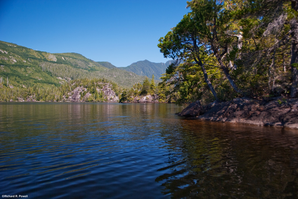
I've driven down the enticing, if impressively root-bound, access road to Maple Lake twice before. In one case it was late in the day and I was worried about the gate closing, and in the other I decided to paddle elsewhere. But I've kept it on my list of lakes to paddle because it looked promising. When John, a long time Vancouver island paddler, suggested we give it a try, I immediately agreed.
John and Paul heading out onto Maple Lake
The boat ramp/put-in is a sandy area scooped from a sandy bank on the eastern shore of the lake, accessed via a tunnel under the Island Highway off of Minto Road. The land surrounding Maple Lake has been recently logged but whether by design or happy chance, there is no way to perceive the cut from the lake or access. An examination of the area on Google maps reveals a healthy boarder of trees around the lake. Imagine if all lakes on the island had this healthy buffer! It would increase the recreational experience 100 fold or more.
I was interested to see John's Mohawk Odyssey, a canoe (and canoe company) I have looked at casually in the past. I enjoyed listening to John give his impressions of the boat and the company.
John gave me an opportunity to paddle the canoe and I found it to be responsive, comfortable, maneuverable and good looking. John said the boat really comes into it's own in moving water and invited us to join him on the Salmon River some time -- one of his favorite destinations.
Maple Lake turned out to be a Sedgebender's dream. The eastern shoreline is broken by several inflows, and an expanse of high ground stretches out into a chain of tiny islands surrounded by a diverse wetland and extended marsh.
We enjoyed winding our way in and around the large areas of bull rushes, reeds, and sweet gale.
All the foliage was touched by the coming fall colours and we appreciated the warm sunshine in an otherwise cool day.
We were visited by large dragon flies and by wasps, but fortunately the wasps only seemed to be interested in checking out our bright PFDs and then zooming off to more important things.
We noticed that all the lilly pads had lost most of their leaves, with secondary growth leaves on a few. It looked to me that water levels had dropped and/or a storm had taken the mature leaves away somewhere. It made for an interesting waterscape.
All three of us share an appreciation for the life and scenery of the wetland and stopped to admire this corner of beauty.
As we headed north along the eastern shore we rounded some high ground and I noticed literally thousands of Whirligig beetles doing their mesmerizing dance below the overhanging sweet gale. Here is a good video on this fascinating beetle: http://youtu.be/RIbzOeNcaxE
The gap between peninsula and the little islands is filled with an impressive stand of very tall rushes or reeds, I'm not sure which. They are just off camera to the right in the above photo.
We paddled through a patch of smaller reeds or rushers on the other side of the peninsula. Perhaps some day I will be motivated to sort out the differences in these beautiful aquatic plants.
After emerging from the rushes we made our way to a nice shaded opening in the shoreline and stop for a bite to eat.
While we ate and talked about important subjects of ethnicity, history, and politics another couple arrives at the distant put-in with their canoe. The day was slow and peaceful and the company was good.
The northern shore is steeply sloped with a couple of well used fishing beaches and we made our way across the bay, back into the sunshine and warmth.
There are lots of nooks and cranies on the lake, and we enjoyed investigating them all.
Maple Lake is a beautiful little lake hidden within a few minutes drive from three central island communities. We were all a little impressed at what a gem it really is.
After loading up our canoes we stood and talked and watch dragon flies hunting some sort of "Mayfly" looking gnat over our heads. Out on the water the sun was setting and a dragon fly crash landed on the water, unable to take flight again. We watched it's desperate attempts, even when it was almost completely underwater. All around us life was emerging, thriving, and dying. I thought of Darwin and my recent reading of his work. Nature is endlessly interesting and deep, and I was filled with gratitude to be able to share appreciation of it with others.
Earlier in the day one of the impressive dragon flies landed on John's face, but I wasn't fast enough to catch it on film, even though it stayed on his face for almost a minute.
As the sun set we were hesitant to leave, but finally the falling temperature drove us to our sweaters and vehicles. Another idyllic autumn day on the water on Vancouver Island.
In an effort to keep 100 Lakes on Vancouver Island all about lakes, I will be posting my mushroom related posts to 100 Mushrooms on Vancouver Island. I know, but when you have a good thing going it is hard to deviate too far from it.
Vancouver Backroads Map Book 4th Edition -- Map 14 A5
Atlas of Canada Link: Muriel Lake
Latitude/Longitude:
Degrees, Minutes, Seconds: 49° 7' 37" N 125° 37' 10" W
Decimal Degrees: 49.127° N 125.619° W
UTM Coordinates: 10U 308902 5444878
Topographic Map Sheet Number: 092F04
Trip Date: September 10, 2011
Muriel Lake
Getting to Muriel Lake takes two days. Not because it actually takes two days to drive there from Nanaimo, but because we were not heading to Muriel Lake at all -- we were heading to the recreational forestry camp site on Kennedy Lake, hoping to camp there and then paddle down the river to the Kennedy River Bog.
There are a half dozen shirtless and tattooed young men lazing about or wandering about a semi-permanent looking camp at the Kennedy Lake Rec site when we drive up. We changed our plans for where were will sleep the night.
The next morning we are back, but now the put-in by the Kennedy River bridge is blocked by a car with the hatch up and doors open. We walk down to have a look. A sleepy-sounding couple calls hello from a tent under the bridge, "Did you want to launch your boat? We can move our car," the fellow asks. The back of the car is strewn with underwear, food wrappers, and a tipped over foam cooler. "It's OK," I call back, "I think we are going somewhere else."
The Put-in at the Kennedy River Bridge from my scouting trip in 2008
I thought of the conservative American scholar James Q. Wilson's line, "“Arresting a single drunk or a single vagrant who has harmed no identifiable person seems unjust, and in a sense it is. But failing to do anything about a score of drunks or a hundred vagrants may destroy an entire community.”
There is a certain romance in a lone tramp rambling his way through the outskirts of town, or along a remote wilderness, using his wiles and wits to live free and unencumbered. There is also an icy prickle over the skin when you fall under the gaze of 12 shiftless eyes in decidedly shifty circumstances.
My dad used to say, "In the wilderness the most dangerous animals are usually human," and I have heeded this truism whenever my gut gives me pause.
We head to Muriel with some sense of disappointment and apprehension.
When I visited Muriel lake in 2008 the drive was reasonably pleasant and the put-in looked like this:
I am surprised to see how much the road beyond the Kennedy River Bridge has deteriorated in 3 years. Large rocks now protrude from the hard packed road bed and in places the Pacific Ninebark, Thimble Berry and Salmon Berry, and various other bushes, crowd close at the edges. There is a sense that the road could disappear into the forest from lack of use. One spot in the road has recently been filled with soil, the efforts most likely of whomever frequents the two cabins located on the lake. The road down to the lake is definitely best attempted with 4 wheel drive, but the concern is really getting up afterwards as there are some large exposed rock where rain has washed the gravel away.
View from the Put in -- 2011
We put our canoes in the water and paddle towards the south eastern corner of the lake, between the two islands visible from the put-in and into a bay filled with water shield.
Paul points out several twisted logs resting on rocks and along the shoreline, their curves and patterns exposed and white under the sun.
These two features, weathered wood and exposed rock, are prevalent themes for the lake. The multiple rocky peninsulas are pleasing combinations of stone and contorted pines. The trees show character in the face of what must be hard winters of torrential downpours and heavy snow.
The heat from the sun is intense so we hug the shady shore, enjoying the rugged beauty of each meter of shoreline.
About 1/4 of the way down the lake we pass a steeply sloped cluster of small rocky islands with one pine doing apparently well amid what seems like very sparse soil conditions. I can't help thinking of my favorite Lone Tree Island on Goose Lake.
We glide over shallow areas where we can see long stretches of rock slanting gradually into the depths, or ending at dark precipices.
On the Northern shore dark green bands of growth show the roads and gullies and I'm thankful that for the moment there are no new clearcuts to distract from the pleasing patchwork of new growth and older forest.
After Paddling for about an hour we get out to stretch our legs on a wide stony shelf a foot below the surface of the water. The cool of the water and the shade from the tall trees give us a chance to contemplate the beauty of the place. We watch schools of small fish moving in and out of the shadows and hear what sounds like a frog plop into the water somewhere down the shore.
When we climb back in our canoes we continue down the lake moving in and out of bays and stopping from time to time to admire large cedar trees. Several handsome specimens of Yellow Cedar stand out amid the more numerous Red Cedar.
Nearing the western end of the lake we disturb a pair of osprey who fly from their nest and seem to lure us away, calling and flying and landing in trees and flying again. We follow them for a ways enjoying their uncommon beauty before turning north and then east to head back into the wind along the northern shore.
The largest island on the lake has some impressive cliffs, but from this side we have trouble seeing where the passage is between it and the northern shore. We paddle hard into the wind and then finally find it, slipping through to find a small archipelago of islands behind it with a houseboat/cabin moored in the protected waters between them.
It strikes me as a perfect spot to tie up, but we don't go ashore, not knowing if this is private property or not. Paul notices Christmas lights on the outside and we can imagine spending a cool evening around the pot bellied stove inside with water lapping at the weathered wood outside.
Then it is back into the teeth of a steady wind, powering our way back to the put-in. We get out, boil water for hot dogs and tea, and while away the afternoon eating, putting away our gear, and enjoying a most pleasant spot.
I'm often asked which lakes in Nanaimo are nice to paddle, and for a long time I have hesitated to give an answer because my ideal type of lake is one with minimal human impact or long stretches of wilderness -- qualities hard to find near centers of human habitation. But paddling any water is better than paddling none, so here I try to temper my own ideals and sort out the best quiet water paddling in the city.
There are more than 18 lakes within or near Nanaimo that can be paddled, but only 5 of them have easy access. This post devotes photos and a few paragraphs to each of the main 5, with additional photos and text on 4 of the other lakes that are worth paddling, even though access is a bit more difficult.
Of the 9 I devote space to here, only 3 are really satisfying to a paddler with my aesthetics, and of those 3, only 2 really hold my imagination in the long term. So bear my bias in mind as you read, and feel free to disagree with me in the comments section below!
At the end of the post is information on local lakes which, for various reasons, I can't recommend.
Me on Westwood Lake in Nanaimo
Here are the 18 potentially paddle-able lakes in alphabetical order. I will highlight the 5 easy access lakes in yellow and the other four that are a little harder to access in green.
Lake
Recommendation
Beck Lake
Not recommended
Blind Lake
Not recommended
Brannen Lake
Go if you don't mind power-boats and noise
Cathers Lake
Not recommended
Collier Dam
Go at least once
Divers Lake
Go often
Enos Lake
Go at least once
Green Lake
Go at least once
Harewood Lake
Holden Lake
Go at least once
Long Lake
Go if you don't mind power-boats and noise
McKay Lake
Michael Lake
Priest Lake
Quennel Lake
Go often
Richard Lake
Westwood Lake
Go often
Witchcraft Lake
Brannen Lake
Latitude/Longitude: Degrees, Minutes, Seconds: 49° 12' 50" N 124° 3' 0" W
Decimal Degrees: 49.214° N 124.05° W
UTM Coordinates: 10U 423529 5451788
Topographic Map Sheet Number: 092F01
Brannon Lake has a great parking area, boat launch, and adjacent sandy beach.This is good for launching a canoe, but also good for launching all sorts of other boats.
Brannon is a favorite for wake board and water ski boats, as well as sea-doo operators, so expect noise (including boat stereos with rap music) during the summer months. If you stick to the shore you will be out of the way of the "go fast" gang because of fairly dense weed beds.
The southern and western shores are fairly scenic with a nice rural feel. Fish of some kind were rising in the weeds the day these photos were taken. The lake is often subject to wind, but can be calm and serene after a rain.
Divers Lake
Latitude/Longitude: Degrees, Minutes, Seconds: 49° 12' 8" N 124° 0' 52" W
Decimal Degrees: 49.202° N 124.015° W
UTM Coordinates: 10U 426096 5450439
Topographic Map Sheet Number: 092F01
Divers Lake has a great parking lot close to the lake with a sandy beach
and a nice little bay that is protected from southerly winds.
The above fishing pier is a little way past the put-in and there was a dead trout floating beside the dock the day I was there. There is an informative video about the dock here: http://www.youtube.com/watch?v=sX7LmsVBi4s The pier cost $21,000 and affords easy access to some of the 300 trout that are released into the lake each year.
Divers is a small shallow lake which is completely bordered by marshy expanses of cattails, bullrushes, and Lilly pads. Though there are lots of invasive bullfrogs (watch the video below for hopping, plopping, squeaking fun), there are also herons, bald eagles, and plenty of redwing blackbirds. Here is a HD video I took while paddling around the lake:
Divers is worth paddling for the wildlife and relatively unspoiled shoreline. There has been a bit of human activity in the past, but unlike Green Lake which has similar habitat and is a similar size, the intrusion onto Divers Lake from nearby homes and yards is virtually non-existent or in serious disrepair. Two new buildings are under construction, however, so the wild-like quality of the lake may soon disappear.
Dilapidated dock and new construction in the background.
For sedge benders, this is a pretty idyllic little lake which suffers only from nearby traffic noise and the loud speaker from a nearby car lot. Still, you can't beat the accessibility and lack of power boat activity.
Green Lake
Latitude/Longitude: Degrees, Minutes, Seconds: 49° 13' 48" N 124° 3' 47" W
Decimal Degrees: 49.23° N 124.063° W
UTM Coordinates: 10U 422601 5453579
Topographic Map Sheet Number: 092F01
Green Lake has a fairly good gravel parking lot and a satisfactory put
in, though it is the most rustic of the easy access lakes in Nanaimo.
A little larger than Divers this pretty urban habitat share's with divers the plague of thousands of invasive bullfrogs.
As you paddle around the lake you will hear them squeaking and calling and despite their profusion and voracious habit of consuming every living thing they can fit in their mouths, they are rather handsome little devils.
Green Lake is surrounded on all sides by houses, man-made openings in the shoreline, wharves, and walkways.
The abundance of shoreline human activity on Green Lake reminds me of Fuller Lake in Chemainus but more on the marshy side of the spectrum and less gentile.
Long Lake
Latitude/Longitude: Degrees, Minutes, Seconds: 49° 12' 35" N 124° 1' 23" W
Decimal Degrees: 49.21° N 124.023° W
UTM Coordinates: 10U 425467 5451288
Topographic Map Sheet Number: 092F01
Like Green Lake the shore of Long Lake is dominated by human presence.
If you like paddling past million-dollar (and multi-million dollar) homes and docks crowded with
expensive boats, sea-doos, and float planes, this is the lake for you.
If you are looking for natural shoreline with wildlife and interesting habitat, you will have to look pretty hard to find it.
One of the more amusing aspects of Long Lake is captured in the above photo. Many houses on the lake have sleek expensive power boats and/or Seadoos and right beside them ugly, poorly designed, cheap plastic canoes and kayaks. It is clear that for these folks the world of quality self propelled water craft is not even on the radar.
The day I took these photos this plane took off, several power boats zoomed around and there were two Sea-doos towing inflated rings behind them with lots of shooting, laughing, and hand waving. It was like a Mad Magazine cartoon to me, but obviously lots of people like this kind of fun.
As I cruised along the shore returning to the boat ramp I crossed the buoy line that marks the swimming area to take a picture of the curve of beach. Within seconds the park security was heading my way. No boats inside the swimming perimeter I guess, even when no swimmers are in sight. I backed out and paddle around. The man has to do his job and I don't begrudge him taking it seriously.
On such a busy lake I guess there have to be lots of rules. It pained me a bit to think that many people are introduced to canoe and kayak paddling on this lake via the Nanaimo Canoe and Kayak Club's activities. Not that I am critical of NCKC. They are doing what they like and doing it well.
But for someone like me, a connoisseur of a different kind of paddling experience, Long Lake has all the attraction of a shopping mall parking lot -- and I mean that in the worst possible way. Racing canoes and kayaks amid power boats and airplanes just feel stressful to me. I paddle to relieve stress, but I know that many others paddle to get the adrenaline pumping.
Still, after most daytime guests have left the lake and the sun is descending to the horizon, the careful paddler can find calm and beauty even among the garish opulence of a heavily urbanized lake like Long Lake.
Westwood Lake
Latitude/Longitude: Degrees, Minutes, Seconds: 49° 9' 46" N 123° 59' 52" W
Decimal Degrees: 49.163° N 123.998° W
UTM Coordinates: 10U 427258 5446045
Topographic Map Sheet Number: 092G04
Westwood Lake is my favorite lake to paddle in Nanaimo because it
combines a wide wonderful sandy ramp for launching with several
kilometers of shoreline featuring intermittent forest, sandy beach, and rocky promenades.
Westwood Lake is heavily used by swimmers (a long sandy beach), anglers (lots of fish
year round), and recreational paddlers. A ban on gas motors means the boats that are on the water are quiet.
The Swimming Beach with Boat Ramp behind it at Westwood Lake
It is also a little higher than most of the other lakes in Nanaimo, and therefore more subject to icing over in the winter. This is meliorated somewhat by it's size and depth. Collier Dam, for example, will often freeze over sooner, even though it is 100 meters or more lower in elevation.
One of the great things about Westwood is the overhanging tree branches and rocky outcroppings along the shore.
In many places you can paddle along right beside the trees, in fairly deep water. But be careful, there are many snags in the water that are just below water level. I have run up on a few over the years.
Enos Lake
Latitude/Longitude:
Degrees, Minutes, Seconds: 49° 16' 43" N 124° 9' 20" W
Decimal Degrees: 49.279° N 124.156° W
UTM Coordinates: 10U 415948 5459099
Topographic Map Sheet Number: 092F08
Enos Lake is surrounded by private land in Nanoose. You have to carry your canoe down a fairly long road (25 meters) in order to access the lake. While we were paddling the lake we chatted with some folks on the shore and one local fellow said, "I didn't think canoes were allowed on the lake." But there were no signs indicated that it was not allowed.
Enos Lake Put-in
The Lake is special in part because it is the home to an endangered species of Stickleback known as the limnetic Enos Lake stickleback. This curious looking fish lives nowhere else except in Enos Lake. It is threatened by development and the introduction of non-native species to the lake.
Add caption
I can't see how gentle paddlers on the lake could negatively effect the little fish, but still, it might be something to consider in the long run.
Given it's proximity to Nanaimo (about a 20 minute drive) and given it's remote feel, I expect more folks will want to paddle this lake. The owner of the surrounding land has applied to develope the area, and seems to be proceeding with a responsible degree of public consultation, so I am hopeful this unique resouce will get the respect and protection it deserves.
Holden Lake
Latitude/Longitude: Degrees, Minutes, Seconds: 49° 6' 10" N 123° 49' 30" W
Decimal Degrees: 49.103° N 123.825° W
UTM Coordinates: 10U 439767 5439232
Topographic Map Sheet Number: 092G04
Holden Lake is boardered on the Eastern side by Hemmer Provincial Park. The Provincial Park website description lists canoeing as one of the activites in the park, but the portage from the park parking lot is a long one (about 300 meters). Alternatively the lake can be accessed from Bean Road off Holden Corso Road.
At the bottom of Bean Road there is a small parking spot and a short muddy walk to the water.
Beware of dogs at this location as the place is swarming with them. They didn't bother me the time I visited, but there sure was a lot of barking -- some from behind fences, some from up the hill on the road.
On the lake you feel pretty peaceful -- it is mostly surrounded by the park on one side and large stretches of farm land on the other.
I also came across a curious water plant while paddling the lake. Does anyone know what this is?
Quennel Lake
Latitude/Longitude: Degrees, Minutes, Seconds: 49° 4' 34" N 123° 48' 49" W
Decimal Degrees: 49.076° N 123.814° W
UTM Coordinates: 10U 440566 5436243
Topographic Map Sheet Number: 092G04
Quennel Lake is somewhat of a hidden gem in Nanaimo. Access is relatively easy if you have some pocket change, or difficult if you just don't like paying to paddle on public water.
The only really convenient way to access Quennel if via the ZUIDERZEE CAMPGROUND & RESORT. The good folks at Zuiderzee will charge you a small fee for the privilege and it may be worth it. Aside from their floating dock, they have a wooden ramp into the water that is really very nice for launching a canoe.
Zuiderzee Waterfront
There is one other put-in for the lake located on Ritten Road, which is off of Yellow Point Road. The ramp here is rutted, muddy, and has steep and bushy sides making it difficult to launch without getting very muddy. There are often trucks and trailers parked all around the ramp. I'm not sure who's jurisdiction this ramp falls under, but given the extensive use it receives I would suggest that several tons of clean fill, gravel, and maybe even cement be dedicated to improving this launch spot.
The Lake is a collection of connected chanells roughly in the shape of a Y next to an H or two H's next to each other. The large central island has one house on it and a short road, very rural looking and scenic.
There are some nice open stretches of water and the vistas in all directions feel expansive and cultured, like I might imagine a lake in Europe would feel.
There are not many places to take out and have your lunch, but there is one on the most westerly chanel. The house directly accross from this spot, however, is inhabited by vigilant residents who must have seen a lot of shenanigans over the years as they are quick to run off anyone who doesn't seem to be fully respecting the fact that the land around the lake is private property.
There are a good number of houses on the lake, but unlike Green or Fuller there are still long stretches of pleasant farmland, forest, and marsh.
I'm not sure what the actual linear dimensions of the shoreline is, but it is quite significant and there are many little bays and corners filled with lilly pads and bull rushes.
Many of the houses that are visible are quaint or well healed into the surrounding landscape and the folks we encountered on the eastern side of the lake were very gracious and friendly. There was a nice feel of neighborly contentment.
Of all the lakes in and around Nanaimo, Quenell is by far the most varied in scenery, diverse in habitat, and charming in character. Note that at certain times of the year the lake can be congested with anglers due to fishing derbies.
Collier Dam Park
Collier Dam Park has two lakes, both accessible to the canoeist. I have previously posted about these little lakes so please see that post for further details.
Other Nanaimo Area Lakes Beck Lake -- If you look hard you will find access to this lake just south of Nanaimo. Access is through a landscape that harkens back to the coal mining years and a 4 wheel drive vehicle is recommended. I've visited this lake on two occasions, once with my canoe on my roof rack, but both times have gone elsewhere.
Blind Lake -- There is direct road access to this small lake off of Nanaimo River Road. Because of it's size and relatively uninteresting surroundings, I have not included Blind Lake in my photo log.
Cathers Lake -- There is access to Cathers Lake on the Northern end. Because the lake is surrounded by houses, some of them pretty close to the water, it felt like I would be paddling in everyone's back yard, so I did not launch.
Harewood Lake -- I have so far not found public access to this lake.
Priest Lake -- I have so far not found public access to this lake.
McKay Lake -- This gem of a lake is currently on my "unknown status" list. I have seen it advertised for sale online, and like with other Timberland and Timberwest lands, access is uncertain from one season to the next. I have visited it in the past and found it charming, but not within the last few years. There are large no trespassing signs on the road into nearby Timberland Lake, so I would not be surprised if McKay has suffered the same fate of too many rowdies tearing up the place to allow continued public access.
Michael Lake -- This south Cedar lake looks interesting on the map, and I have gazed upon it from afar, but have so far been unable to find access to the water.
Richard Lake -- access to this Cinnabar Valley lake is uncertain. I have visited it several times looking for access and each time have felt that near water locations may be private property, so I have not ventured further. It is a pretty little spot with lots of fish rising, but also near a dirt farm, so I would not go on a windy day.
Witchcraft Lake -- This hidden lake on the slopes overlooking Nanaimo is small and covered with dead-fall. There is a nice bridge across the lake, but I have not explored the area enough to confirm a good place to launch a canoe.
Still Others... Long Lake in the Ladysmith Eco Reserve -- Would require a long carry (200 plus meters) and I am uncertian if watercraft are allowed on the lake. If they are, it might be worth it as it is a beauty.
Morrell Lake -- Within the Morrell Sanctuary and a long hike past the
gate. I plan to ask the Sanctuary folks about paddling this lake some
day as I walk past it on longer walks from my house and it calls to me often.
Myles Lake -- I have not tried to visit this lake.
Stark Lakes -- I have not tried to visit these lakes.
Overton Lake -- I have not tried to visit this lake.
Whiskey Lake -- looks interesting on Google Earth, but the access seems pretty convoluted. Maybe someday I will give it a try.


